|< First   < Prev     Info   3  of  29    Play    Next >   Last >| 

Click for the original image

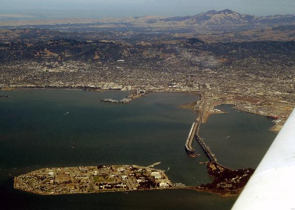
Comment:  Being clear of the SFO and OAK airport traffic, Julie was cleared to climb. This picture of the east side of the San Francisco Bay was taken from about 4000'. Berkeley is on the left, Oakland on the right. The new Bay Bridge construction is clearly visible. The spit of land sticking out into the bay to the left of the Bay Bridge is Emeryville. Scott and Tiffany lived in low brown roofed buildings in the middle of the spit when they first moved out to the San Francisco area. The two connected islands in the foreground are Treasure Island on the left and Yerba Buena Island on the right. Treasure Island (man made) been used as an international airport, site of the 1939-40 World's Fair and as a military base. Yerba Buena connects the two sections of the Bay Bridge. Clipper Cove, the water between the islands is named for the airplanes that took off from there before WWII. Also in the foreground, to the right just below Julie's wing, is the Port of Oakland with its container cranes. The large white building at the base of the hills beyond Emeryville is the Claremont Hotel, dating from 1915. To the left of Emeryville, also at the base of the hills is the University of California at Berkeley. Identifying campus features include the tall Campanile tower and the narrow horizontal ellipse that is the top edge of California Memorial Stadium. Left of the campus, between it and the water over Berkeley is a Goodyear Blimp. Dominating the background, about 25 miles away, are the twin peaks of Mt Diablo. The northern peak (on the left) is 3,557' high. The taller southern peak is 3,849'. Mt Diablo is the primary visual landmark used by pilots in the Northern California area. Even when the marine fog layer comes in, it can be seen poking through the clouds providing a sign post for the Sand Francisco area
Image Date:  Aug 10, 2007 - 02:57 PM
Original:  PICT1681ac.jpg , 1.66 MB,  2800 x 2000
Gallery:  San_Carlos_to_Twin_Oaks_Flight_Album
Camera:  MAXXUM 5D
Settings:  Focal len: 243 mm, Exposure: 1/200s, Aperature: F13.0
PhotoDawg skin for JAlbum 7.2 created by David Hart
Album last updated on Oct 30, 2007 - 07:49 PM
Copyright (c) 2007, Edward E Cragg
General info:
ModelMAXXUM 5D
MakeKONICA MINOLTA
Basic shot info:
Focal Length50.0 mm; equivalent: 243 mm
Exposure Time1/200 sec
White BalanceAuto white balance
FlashUnknown flash mode
Metering ModeMulti-segment
ISO Speed Ratings100
Advanced shot info:
Exposure Bias Value0 EV
Exposure ModeAuto exposure
Brightness Value9.87
ContrastNone
SaturationNone
SharpnessNone
Exif-related info:
Exif Version2.21
Exif Image Width2800 pixels
Exif Image Height2000 pixels
Color SpacesRGB
CompressionJPEG (old-style)
ArtistEdward E Cragg
CopyrightCopyright (c) 2007 by Edward E Cragg. All rights reserved.
Image DescriptionThe east side of the San Francisco Bay. Berkeley is on the left, Oakland on the right. Mt Diablo (3,849') is in the background. The new Bay Bridge construction is clearly visible. The spit of land sticking out into the bay to the left of the Bay Bridge is Emeryville, where Scott and Tiffany lived when they first moved out to the San Francisco area. Visible on the far left, over Berkeley is a Goodyear Blimp.
User CommentBeing clear of the SFO and OAK airport traffic, Julie was cleared to climb. This picture of the east side of the San Francisco Bay was taken from about 4000'. Berkeley is on the left, Oakland on the right. The new Bay Bridge construction is clearly visible. The spit of land sticking out into the bay to the left of the Bay Bridge is Emeryville. Scott and Tiffany lived in low brown roofed buildings in the middle of the spit when they first moved out to the San Francisco area. The two connected islands in the foreground are Treasure Island on the left and Yerba Buena Island on the right. Treasure Island (man made) been used as an international airport, site of the 1939-40 World's Fair and as a military base. Yerba Buena connects the two sections of the Bay Bridge. Clipper Cove, the water between the islands is named for the airplanes that took off from there before WWII. Also in the foreground, to the right just below Julie's wing, is the Port of Oakland with its container cranes. The large white building at the base of the hills beyond Emeryville is the Claremont Hotel, dating from 1915. To the left of Emeryville, also at the base of the hills is the University of California at Berkeley. Identifying campus features include the tall Campanile tower and the narrow horizontal ellipse that is the top edge of California Memorial Stadium. Left of the campus, between it and the water over Berkeley is a Goodyear Blimp. Dominating the background, about 25 miles away, are the twin peaks of Mt Diablo. The northern peak (on the left) is 3,557' high. The taller southern peak is 3,849'. Mt Diablo is the primary visual landmark used by pilots in the Northern California area. Even when the marine fog layer comes in, it can be seen poking through the clouds providing a sign post for the Sand Francisco area