| ▲ Up ▲ | |||||
. To me the most interesting part of this trip was zipping through the former Iron Curtain border between the Czech Republic and Germany. While the old border control buildings and empty no-man's land were still visible, we just drove right through. For access and loading convenience the Viking Legend loaded passengers a couple of miles downriver from Passau. After dinner and the \"Welcome Aboard\" introductions, the boat moved to its downtown Passau dock. This picture was taken on the approach to Passau. The lit up towers on the left are the St. Stephen's Cathedral. The lit tower in the center is the Old Town Hall. Finally the lit building on the right is the \"Veste Niederhaus\" (Lower Fortress). The darken tower in the center is the St. Paul Church, while the two darken towers on the left belong to something called \" K.D.St.V. Oeno-Danubia im CV\" which is not otherwise mentioned in the guide books. The boat docked just beyond the St. Paul Church.") Movement of the Legend to Passau Viking River Cruise provided bus transportation from Prague to Passau, Germany (where the cruise was to begin). To me the most interesting part of this trip was zipping through the former Iron Curtain border between the Czech Republic and Germany. While the old border control buildings and empty no-man's land were still visible, we just drove right through. For access and loading convenience the Viking Legend loaded passengers a couple of miles downriver from Passau. After dinner and the "Welcome Aboard" introductions, the boat moved to its downtown Passau dock. This picture was taken on the approach to Passau. The lit up towers on the left are the St. Stephen's Cathedral. The lit tower in the center is the Old Town Hall. Finally the lit building on the right is the "Veste Niederhaus" (Lower Fortress). The darken tower in the center is the St. Paul Church, while the two darken towers on the left belong to something called " K.D.St.V. Oeno-Danubia im CV" which is not otherwise mentioned in the guide books. The boat docked just beyond the St. Paul Church.   Movement of the Legend to Passau |
 High Altar in St. Stephen's Cathedral Created in 1953, this altar shows the stoning of St. Stephen, the first Christian martyr. It was carved out of poplar wood with rolled silver sheet covering.  High Altar in St. Stephen's Cathedral |
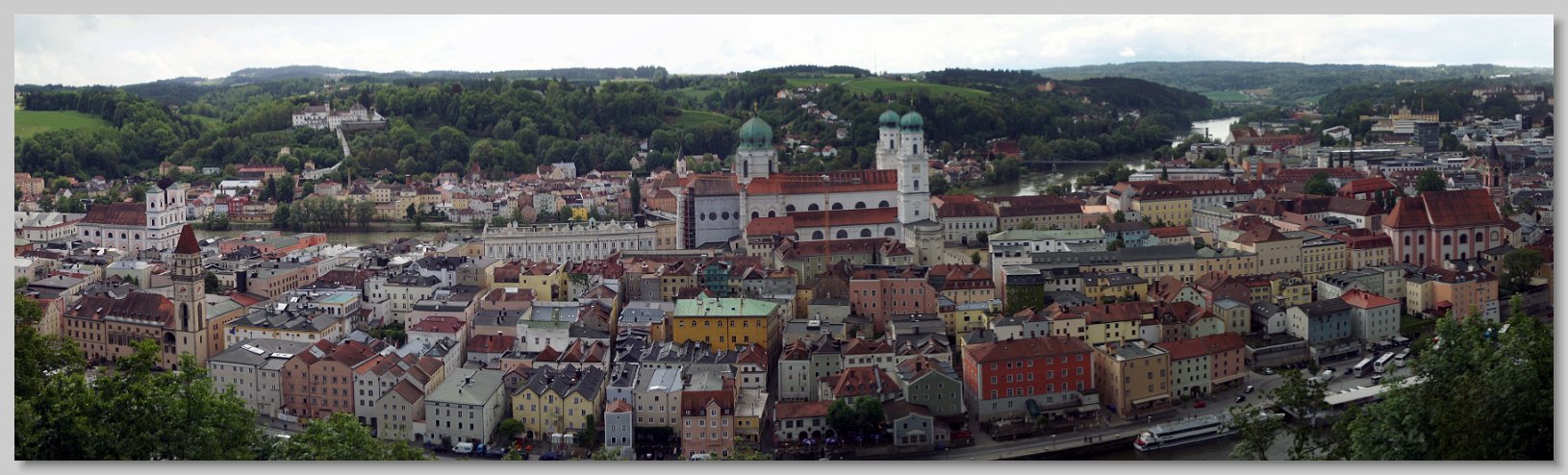
Old Town Passau Panorama from the Upper Fortress This is a panorama of Passau taken from a walking trail on the opposite bank of the Danube. The Old Town Hall can be seen in the lower left. St. Stephen's Cathedral is in the center, and the St. Paul Church is on the right edge. At the very bottom right are some boats docked along the Danube. The Inn river is on the other side of the town, coming in from the upper right in the distance. Finally the building complex on the far side of the Inn river near the top of the hill is Pilgrimage Church and Pauline Fathers' Monastery. The curved structure leading up to it is the "heavenly ladder” - a 321 steps is a covered staircase leading from the Inn river to the top of the church. Traditionally pilgrims kneel and pray at each step, approaching the place of grace in a particularly memorable manner. This pilgrimage tradition dates back to 1630.  Old Town Passau Panorama from the Upper Fortress |
 and the \"Veste Niederhaus\" (Lower Fortress) can be seen at the base of the hill.") Old Town Passau Viewed from Danube River Bridge This is a view of Passau taken from a bridge over the Danube upstream from the Legend's Dock. The Legend is the innermost of the three docked boats, the one with the bow facing towards the camera. An unexpected occurrence throughout the trip was the docking of the boats side-by-side so that the passengers on the outer boats needed to pass through the other boats to get off. The tall steeple in the middle of the picture is the St. Paul Church. The blue-green towers on the right are St. Stephen's Cathedral. On the opposite bank, the building half way up the hill is the "Veste Oberhaus" (Upper Fortress) and the "Veste Niederhaus" (Lower Fortress) can be seen at the base of the hill.  Old Town Passau Viewed from Danube River Bridge |
 Mirabell Palace Gardens This is a view of Old Town Salzburg taken from in the gardens of Mirabell Palace. This garden was the site used in the movie "Sound of Music" to film Maria and the children singing "Do-Re-Mi". The spires of the Salzburg Cathedral and the Salzburg Castle on the hill above are both visible.  Mirabell Palace Gardens |
. The Salzach River separates old town from down town. The Mirabell Palace is visible on the other side of the river between the cathedral and St. Peter's Church. It is the large building with the green roof.") View of old Town Salzburg from Castle This is a view from the highest tower in the Salzburg Castle looking over Old Town. the green roofed towers in the foreground are the Salzburg Cathedral, dedicated to Saints Rupert and Vergilius, both of whom were significant actors in the founding of Salzburg. Parts of cathedral date back to 774. It has been damaged, repaired, rebuilt, expanded and completely rebuilt many times over the centuries, with the current structure dates from 1628. The tall church spire on the left belongs to the St. Peter's church and associated cemetery. The rectangular building to the right of the cathedral houses the Salzburg Museum and is located on Mozart Square (just beyond the building). The Salzach River separates old town from down town. The Mirabell Palace is visible on the other side of the river between the cathedral and St. Peter's Church. It is the large building with the green roof.  View of old Town Salzburg from Castle |
 in Old Town Salzburg - This is a view looking down Getreidegasse (street) in Old Town Salzburg. At the end of the street is St. Blasius Kirche (Church). Behind the church is the Mönchsberg elevator which takes tourists up or down the cliff to Winkler Terrace. This is a typical Old Town street. Note all the signs hanging out from the buildings to identify the business establishments. At the very end of the street, on the left side, with a royal blue sign hanging out from the building is one of the Paul Fürst Confectionary shops. In 1890 Herr Fürst created a chocolate ball truffle he called the \"Salzburger Mozartkugel\" (Mozart Ball). He showed it at fair in Paris in 1905 and was awarded a gold medal. Since there was no patent/trademark protection available at the time, the Mozartkugel has been widely copied. They also produce a second, rectangular confection named the \"Doppler Kon(Ef)fekt\". The former is in honor of hometown hero Mozart, the latter is to honor Salzburg born physicist Christian A. Doppler of the “Doppler effect”. They were both quite good.") Getreidegasse (street) in Old Town Salzburg This is a view looking down Getreidegasse (street) in Old Town Salzburg. At the end of the street is St. Blasius Kirche (Church). Behind the church is the Mönchsberg elevator which takes tourists up or down the cliff to Winkler Terrace. This is a typical Old Town street. Note all the signs hanging out from the buildings to identify the business establishments. At the very end of the street, on the left side, with a royal blue sign hanging out from the building is one of the Paul Fürst Confectionary shops. In 1890 Herr Fürst created a chocolate ball truffle he called the "Salzburger Mozartkugel" (Mozart Ball). He showed it at fair in Paris in 1905 and was awarded a gold medal. Since there was no patent/trademark protection available at the time, the Mozartkugel has been widely copied. They also produce a second, rectangular confection named the "Doppler Kon(Ef)fekt". The former is in honor of hometown hero Mozart, the latter is to honor Salzburg born physicist Christian A. Doppler of the “Doppler effect”. They were both quite good.  Getreidegasse (street) in Old Town Salzburg |
  Ars Electronica Center Light Show In Linz, across the river from where the Legend was docked, is the ARS Electronic Center. It is a self described " Museum of the Future". Having spent the day in Salzburg, we did not get a chance to go into the museum. However at night the entire building provides a light show on its LED enabled glass facade. After dinner on the boat, I went up the river and took this 15 second video. The Viking Staff joked that the only time you could actually see a "Blue Danube" occurred when the building's facade was lit up blue.  Ars Electronica Center Light Show |
, are on the left, entered from the walkway. It is the largest ecclesiastical library in the world, with over 100,000 volumes of old books and 1186 manuscripts. Most of the books are from the 15th, 16th and 17th centuries with the oldest book being from 988. We were not allowed to take pictures in the library :(") Melk Abbey The earliest mention of the town Melk occurred in 831.It is the best known for a massive baroque Benedictine abby founded 1089. A monastic school was added in the 12th century. The current structure was built between 1702 and 1736. This picture of the abbey was taken from the path between the Legend docking area and the abbey. The church is in the center, below the 200 foot tall central tower and behind two the shorter front towers. There is an open walkway curving around the front of the structure. The Abbey's library, second in importance (after the church), are on the left, entered from the walkway. It is the largest ecclesiastical library in the world, with over 100,000 volumes of old books and 1186 manuscripts. Most of the books are from the 15th, 16th and 17th centuries with the oldest book being from 988. We were not allowed to take pictures in the library :(  Melk Abbey |
 High Altar Melk Abbey Church The Melk Abbey Church is the focus of the abbey. It has a 210 ft central dome with two shorter towers at the front of the church. The interior of the church is richly decorated in the baroque style. There are a large number of windows providing natural light to the interior. Indeed the high altar in this picture was lit with natural light. There is gold, marble and frescos everywhere. Being a good Protestant I have always intellectually understood Martin Luther's complaint about the use of church wealth. Visiting this church drove that understanding into my gut.  High Altar Melk Abbey Church |
. The cruise down the river was extremely windy. The crew had to collapse the chairs on the sun deck to keep them from being blown away. These is a collage of pictures taken during this portion of the trip.") Wachau Valley Cruise The town of Melk is at one end of the Wachau, a 25 mile valley where the Danube meanders through a range of low mountains. With numerous villages, churches, castles, and ruins the valley very picturesque. The area has been continuously lived in since prehistoric times. Roads and railroads run along either bank, but this stretch of the river has no bridges. Having produced wine since Roman times, the valley floor and hills were covered with vineyards. Almost all of the villages had a tall pole with a decorated tree on top. These were "Maibaum" or maypoles (literally May Tree). The cruise down the river was extremely windy. The crew had to collapse the chairs on the sun deck to keep them from being blown away. These is a collage of pictures taken during this portion of the trip.  Wachau Valley Cruise |
 Statue of Richard the Lionheart and Blondel Rounding a meander on the approach to the little town of Dürnstein the Legend encountered this statue. It is of King Richard the Lionheart and the minstrel Blondel. During Richard's return from the Third Crusade he was captured and imprisoned in the castle at Dürnstein. His capture was reported to the English court, but for some weeks the regents did not know where he was being held. This lead to the myth he was found by Blondel, whom he saw from his window, and to whom he sang a verse of a song they both knew. Later versions of the story related that Blondel went from castle to castle, singing a particular song that only he and Richard knew, and that the imprisoned Richard replied with the second verse. Blondel then either aided the king's escape or reported his position back to England. .In fact Richard's location was widely publicized as part of ransom demands  Statue of Richard the Lionheart and Blondel |
 Dürnstein This is Dürnstein, a small town of about 900 people situated below the ruins of the Castle Dürnstein, from which it was named. The castle's name was derived from the German "dürr" meaning dry and Stein meaning stone because it was on a rocky hill, high above the damp of the Danube and was built of stone. This picture was taken from the Legend as she approached the dock. On the left of the picture is the blue tower of the parish church which was originally the monastic church of the Order of St. Augustine founded in 1410. The current monastery buildings were built from 1710-1740 and restored in 1986. The monastery was dissolved in 1788 Most of the houses in the town were originally built during the 15th century. behind the town, not visible due to the buildings are vineyards. There is also an ossuary in the town. It was simply a pile of bones behind a locked door without any of the macabre arrangements seen in Kunta Hora.  Dürnstein |
 Dürnstein Castle Ruins Clearly Dürnstein is exploiting the ruins as best they can. The castle was built around 1130 by family named Kuenringer. It's main claim to fame is that in 1192 King Richard the Lionheart was held prisoner until his release after the payment of a significant ransom. Now ruins, the castle was destroyed by Swedish troops in 1645, during the thirty years war. I hiked up to them. There were two ways to go. I went up using a shorter, very rough hewn, stone staircase. This picture was taken near the top of those stairs just below the ruins.  Dürnstein Castle Ruins |
 View from the Castle Dürnstein Ruins I climbed to the very top of the ruins. This is view from there. The town with its distinctive parish church is below right of center. To the left are vineyards and docked behind the trees is the Legend. Having started out after spending time walking around the town and not being as fast as I once was, most of the other cruise visitors were leaving as I arrived. I had the ruins pretty much to myself. There were a number of cut and painted sheet metal markers around the ruins giving details on Richard's impact on history, myth, literature, music and movies stretching down to the present day. Not wanting to risk going down the staircase, I chose to take the longer path back to the town. Along the path I found more of the markers. I barely made it back to the Legend in time for dinner.  View from the Castle Dürnstein Ruins |
 Castle Dürnstein Ruins at Night While I was up on the castle ruins I noticed a number of flood lights aimed at it. After dinner and sunset back on the Legend, but before its departure, I disembarked and took pictures of the lit up castle. Not having a tripod I had to run the camera's ISO rating up very high to get any pictures. This is the best of the lot.  Castle Dürnstein Ruins at Night |
 St. Stephen's Cathedral Thanks to the weather Vienna was disappointing. It was too rainy to take many pictures. Fortunately there was a small break in the weather and I was able to take this composite picture of the St Stephen's Cathedral. The church was first founded in 1137. At the time Vienna was under the Prince-Bishop of Passau, so the church was dedicated in 1147 to St. Stephen in honor of the patron saint of the cathedral in Passau. Much of this original building was destroyed by a fire In 1258. A larger replacement structure which incorporated two towers from the original building was constructed over the ruins of the old church. Subsequently the church was expanded. The main tower was build from 1368 to 1433. In 1469 the church became a cathedral upon the appointment of a Bishop for Vienna. At 445 feet tall, the main tower is the highest point in the city. It contains an apartment for watchmen who, until 1955, manned the tower each night and rang the bells if a fire was spotted in the city. There is a partially constructed second tower on the opposite side of the church. Meant to mirror the existing tower, construction on it was halted in 1511 at 223 feet  St. Stephen's Cathedral |
 St. Stephen's Cathedrial Interior This picture is of the inside of St. Stephen's Cathedral, looking down the nave at the High Altar. It was built as part of a refurbishment of the church in 1641 As in the St. Stephen's in Passau, the altar is a representation of the stoning of St. Stephen.  St. Stephen's Cathedrial Interior |
, but is frequently called the UFO bridge. It is an asymmetrical cable-stayed bridge. The total length of the bridge is 1,413 ft and its width 69 ft. The top deck accommodates 4 lanes of vehicular traffic only, the lower deck provides paths for pedestrians and cyclists. There is a restaurant called \"UFO\" at the top of the tower. On top of the restaurant is an observation deck, 277 feet high.") UFO Bridge The Legend's next stop was Bratislava Slovakia, located about 45 miles down the Danube from Vienna. The boat was docked under a bridge that appeared to have a flying saucer over it. Officially this bridge over the Danube is named Most SNP (Bridge of the Slovak National Uprising), but is frequently called the UFO bridge. It is an asymmetrical cable-stayed bridge. The total length of the bridge is 1,413 ft and its width 69 ft. The top deck accommodates 4 lanes of vehicular traffic only, the lower deck provides paths for pedestrians and cyclists. There is a restaurant called "UFO" at the top of the tower. On top of the restaurant is an observation deck, 277 feet high.  UFO Bridge |
 are old town. The top of the Legend can just barely be seen to the left of the roadway at the bottom of the picture.") Panoramic View from UFO Bridge Observation Deck To get to the observation deck, I walked across the lower pedestrian level of the UFO bridge. The walkway had a series of pictures showing the construction of the bridge. I took this panoramic picture from the top of the bridge. The Bratislava Castle is the large building on top of the hill on the left. From 1531-1783 it was the main castle of the kingdom of Hungary. The leftmost tower, known as the crown tower, is larger and taller than the other three. It used to house the Hungarian crown Jewels, now to be found in the Hungarian Parliament Building in Budapest. The large church just to the right of the road is St. Martin's Cathedral originally on the edge of old town Bratislava. St Martin's is noted for being the coronation church of the Kingdom of Hungary between 1563 and 1830. The red-roofed buildings on the right of the picture (to the right of church) are old town. The top of the Legend can just barely be seen to the left of the roadway at the bottom of the picture.  Panoramic View from UFO Bridge Observation Deck |
 Bratislava Wimsical Statues - Napoleonic Soldier In an attempt to shed the somber grayness of the Communist era a number of whimsical statues have been placed in the old town. This is a bronze statue of a Napoleonic soldier leaning over a bench in the main square. His purpose is to serve as a reminder of Napoleon's two "visits" to Bratislava, first in 1805 and again in 1809. The statue shows the soldier wearing a typical Napoleonic hat. With all the tourists either posing for pictures or taking selfies on the bench, getting this photo required a bit of patience and some adept cropping.  Bratislava Wimsical Statues - Napoleonic Soldier |
 flowers. According to the tour guide, the statue is meant to bring his joyful spirit to the streets of Bratislava.") Bratislava Wimsical Statues - Schone Naci This statue is of a renowned character from early and mid 20th Century Bratislava. His real name was Ignác Lamár, with "Schone" translating to "pretty" and "Naci" being a diminutive of Ignác. He was born on 11 August 1897 to family of a shoemaker in Petržalka and died of tuberculosis on 23 October 2967 in Lehnice. A poor and mentally ill man, he paraded the streets of Bratislava in donated old, but elegant attire - a top hat and a tailcoat. He would greet women with the words, “I kiss your hand” in German, Hungarian & Slovak, sing to them, or even give them (donated) flowers. According to the tour guide, the statue is meant to bring his joyful spirit to the streets of Bratislava.  Bratislava Wimsical Statues - Schone Naci |
 is simply resting, (2) has just cleaned the sewer, or(3) is enjoying looking up women's skirts or. Several times he has lost his head to reckless car drivers so the authorities installed the much abused \"Man at Work\" sign next to him. All three statues were installed in 1997 as part of the establishment of the pedestrian zone in Old Town.") Bratislava Wimsical Statues - Cumil. Man at work While it was the last statue seen on the tour, Cumil, a workman poking his head out from a manhole watching passersby, is probably the best known of the whimsical statues - at least it has the highest rank of the three on Trip Advisor - things to do in Bratislava. Locals claim he: (1) is simply resting, (2) has just cleaned the sewer, or(3) is enjoying looking up women's skirts or. Several times he has lost his head to reckless car drivers so the authorities installed the much abused "Man at Work" sign next to him. All three statues were installed in 1997 as part of the establishment of the pedestrian zone in Old Town.  Bratislava Wimsical Statues - Cumil. Man at work |
 Grey Heron Collage After departing Bratislava at lunch time, the Legend made its only daytime passage through a lock at the Gabčíkovo–Nagymaros Lock and Dam complex. In addition to two 60' navigation locks the complex includes 270 MW electrical generation facilities, a road bridge over the Danube and the Čunovo Water Sports Centre featuring Europe's largest white water facility. We waited in line for over 90 minutes to be able to enter the lock and it took 45 minutes for the lock to cycle so This collage is made up of two pictures of the same grey heron which landed on the upstream lock gate right after it closed.  Grey Heron Collage |
 Esztergom Basilica The Brits on the cruise had a saying: "ABC" which could stand for either "Another Bloody Church" or "Another Bloody Castle". This ABC is the "Primatial Basilica of the Blessed Virgin Mary Assumed Into Heaven and St Adalbert" also known as the Esztergom Basilica. This is a view of the rear of the church as seen from the river. It is seat of the Catholic Church in Hungary and is the biggest church in Hungary, the third largest church in Europe, and the 18th biggest church in the world. Cardinal József Mindszenty, who was granted political asylum in the United States Embassy in Budapest from 1956 to 1971, is buried in the basilica's crypt. It is located in the town of Esztergom which was established about 972 AD. The town was the birth and coronation place of St. Stephen, the first Hungarian king. It was also the capital of Hungary until the 13th century. This picture was taken from the boat as we cruised past during dinner.  Esztergom Basilica |
 Buda Castle at Night from the Danube River The Legend entered into Budapest after dark. The cruise director promised that the approach would be spectacular, and indeed it was. The major buildings along the banks were all lit up. This picture is the Buda Castle on Castile Hill. The original castle was built between 1245 and 1265. The current castle dates from 1765. It has since been extensively rebuilt and, after war damage, repaired.  Buda Castle at Night from the Danube River |
 and Fisherman's Bastion (in the front). Only a small portion of Fisherman's Bastion is visible, the remaining parts being behind unlit buildings.") Matthias Church and Fisherman's Bastion at Night from the Danube River This lit up complex, also on Castle Hill, is the Matthias Church (to the rear) and Fisherman's Bastion (in the front). Only a small portion of Fisherman's Bastion is visible, the remaining parts being behind unlit buildings.  Matthias Church and Fisherman's Bastion at Night from the Danube River |
 Hungarian Parliament Building at Night from the Danube River The most spectacular lit building is the Hungarian Parliament Building. It is on the Danube's bank. A shadowy cruise boat is in the front of the picture.  Hungarian Parliament Building at Night from the Danube River |
. It was designed an English engineer and construction began in 1839 and completed in 1849. Its total length is 1230 ft, with a central span of 663 ft. When constructed it had the second longest suspension bridge span in the world. From 1913 to 1915 it was significantly rehabbed and strengthened to support heavier motor vehicles. In 1945 retreating Germans blew up everything except the two pillars. An exact copy of the original was rebuilt from 1947 to 1949. The bridge's suspension chain links resemble elongated bicycle chain links. The light dot in the sky above the bridge is the Moon peeking through the clouds.") The Chain Bridge at Night from the Danube River Officially known as the Széchenyi Chain Bridge, this is a view from the river at night just before the Legend passed under the bridge to dock on the left side below the bridge. The Chain Bridge was the first permanent bridge across the Danube in Hungary and the second along the river's entire length (after a bridge in Vienna). It was designed an English engineer and construction began in 1839 and completed in 1849. Its total length is 1230 ft, with a central span of 663 ft. When constructed it had the second longest suspension bridge span in the world. From 1913 to 1915 it was significantly rehabbed and strengthened to support heavier motor vehicles. In 1945 retreating Germans blew up everything except the two pillars. An exact copy of the original was rebuilt from 1947 to 1949. The bridge's suspension chain links resemble elongated bicycle chain links. The light dot in the sky above the bridge is the Moon peeking through the clouds.  The Chain Bridge at Night from the Danube River |