
Baranov Totem Pole
My cousin John met me at the Sitka Ferry Terminal. After a quick stop at my motel to check in and drop off my luggage, he took me for a road tour around Sitka - 14 miles from end to end. After he dropped me off back at my motel I change and headed out for a down town walkabout. My first stop was Totem Square, the central focus of which is this 40 foot "Baranov Totem Pole". The pole was carved to commemorate the peace treaty that Russian American Company manager Alexander Baranov brokered in 1805 between the Russians and the Sitka Tlingit. Originally raised 1942, it was removed in 2010, restored and reinstalled in 2011. From the top, it's carvings include Baranov, a Russian bear, Sitka Tlingit leader Katlian, a Tlingit raven, a Russian double headed eagle, a brown bear, and finally a frog emerging from a knothole. Controversially, Baranov is carved without clothes.


Baranov Totem Pole

Sitka Pioneer Home
On the opposite side of Totem Square from the Baranov Totem Pole is the Sitka Pioneer Home. It is an assisted living home operated by the state, caring for up to 65 residents. In addition to it's assisted living role, it also plays a large part in Sitka's Alaska Day festivities. The parade through downtown ends close to the grounds and hundreds of people mingle at a free reception inside the home with live entertainment traditionally provided by the New Archangel Dancers. The annual Alaska Day croquet tournament takes place on the grounds at the same time.

Sitka Pioneer Home

Prospector Statue
TThis statue, entitled The Prospector, sculpted by Alonzo Victor Lewis, is as the centerpiece of the Sitka Pioneer Home grounds. The sculpture was supposed to be modeled after real-life pioneer William "Skagway Bill" Fonda. A second, smaller version of the sculpture is in Seattle's Klondike Gold Rush National Historic Park. In addition to the appropriate credits, the plaque on the statue quotes the final verse of Canadian poet Robert W Service "The Spell of the Yukon" -- "There's Gold and it's haunting and haunting. - It's luring me on as of old - Yet it isn't the gold that I'm wanting - So much and just finding the gold. - It's the great big broad land way up yonder. - It's the forest where silence has lease. - It's the beauty that fills me with wonder. - It's the stillness fills me with Peace."

Prospector Statue

Down Town Sitka - Lincoln Street
This is the main tourist street in Sitka. Fortunately for me, since Sitka does not have the massive cruise liner trade of Ketchikan and Juneau it was not totally deserted. only about a quarter of the shops were closed for the season. I had several meals in Homeport Eatery, purchased a number of souvenirs at the Sitka Bazaar, an "O is for Orca" book at Harbor Books, and more excellent chocolate than I should have at Chocolate Moose. The church at the end of the street is St Michael's Cathedral.

Down Town Sitka - Lincoln Street

St. Michael's Cathedral
St Michaels Orthodox Cathedral is the central tourist attraction in Sitka. The original cathedral was built between 1844 and 1848. It was in continuous use until it burnt down in January 1966. Fortunately in 1961 the Historic American Buildings Survey, sponsored by the National Park Service, had made a complete set of drawings of the cathedral. This replica of the Cathedral was rebuilt based on these drawings at the same location and to the same measurements, but with modern fireproof material .

St. Michael's Cathedral

St. Peter's By The Sea Episcopal Church
Further along Lincoln Street, across from Crescent Harbor, is St. Peter's By The Sea Episcopal Church, built in 1899. An unusual feature of this church is that in the center of the rose stained glass window at the front of the church is a Star of David. The original construction of the church left a circular opening for a stained glass window. An order for a window with Christian symbols, to fit in the opening, was placed from a supplier of church windows, somewhere in the eastern portion of the United States. After many months the window arrived. When uncrated it was discovered that instead of the Christian symbol that was ordered, a six pointed Star of David was in the center. Much debate followed. Since the window was the correct diameter for the opening and it would take a long time to get a replacement, they decided to install it anyway. According to their web site history page: "For close to 100 years, this Star has reminded the worshippers of St. Peter's of the beginnings of our Christian faith."

St. Peter's By The Sea Episcopal Church

John O'Connell Bridge
The John O'Connell Bridge, named for a former Sitka mayor, is a cable-stayed bridge that connects the town of Sitka on Baranof Island to the airport and Coast Guard Station on Japonski Island. Built in 1971, he two-lane bridge is 1,255 feet long, with a main span of 450 feet. This picture was taken from the boat at the end of Saturday's wildlife cruise. Before the bridge was built, a ferry service connected the two islands, much like the situation in Ketchikan. Just below the bridge you can see a gang way structure. Since there are no deep water docking facilities, cruise ships anchor in the sound and use small tenders to ferry passengers to the town. The tenders dock at this facility.

John O'Connell Bridge

Down Town Sitka From The John O'Connell Bridge
I took this picture of downtown Sitka from the far side of the John O'Connell Bridge. The city has a year around population of nearly 9000. In the center of the picture, below the mountains which form the back drop to the city, is Totem Square. The Pioneer Home is visible in the center. In front of the home, almost hidden by the front door and flag pole is the Baranov Totem Pole. To the right is Lincoln Street with the St Michael's Cathedral front steeple visible.

Down Town Sitka From The John O'Connell Bridge

Castle Hill
Castle Hill is a 60 foot high a rock outcropping on the edge of Sitka Harbor. Originally it was extremely prominent on the water's edge, however it is now set back several hundred feet by harbor fill. Due to this setback and downtown buildings it took me a while to realize it was the hill and not one of the local buildings. In 1867, when Russian Alaska was transferred to the United States the first United States flag was raised on this hill. Again in 1959 when Alaska was admitted as a state the first in-state 49 star flag was also raised here. Over the centuries many different settlements, and buildings were built on it. When the US purchased Alaska the Russian Governor's house occupied the site. The US Army, followed by various other government offices used the house until 1932. It was subsequently used commercially until 1955 when it was demolished. Since then it has been a park. It is now the Baranof Castle State Historic Site, and is considered a National Historic Landmark. The top is mostly surrounded by a stone parapet with interpretive plaques, six cannons and a flagpoles. This picture was taken from the John O'Connell Bridge. The handrails mark a tourist path going up the hill. The two trees framing the hill are Sitka Spruce, growing from the base of the hill.

Castle Hill

Harbor Island Houses
Just below the bridge on a small treed island were these two picturesque houses.

Harbor Island Houses
 Bickar flew in and ignited 100 old tires in the crater, convincing nearby residents of Sitka, Alaska that the volcano was erupting. Round the rim of the volcano the words \"April Fool\" were spray painted in 50ft letters. The prankster's favorite response came in 1980 when he received a letter containing a newspaper clipping with a photo of Mt. St. Helens erupting. Attached was a note that read, \"This time you've gone too far.\" This picture was taken from the far side of the John O'Connell Bridge over the Sitka Channel.")
Mount Edgecumbe
Mount Edgecumbe is a dormant, symmetrical, 3,201 foot stratovolcano on southern Kruzof Island about 10 miles due west of down town Sitka. The volcano was the subject of a notable April Fools prank in 1974. A Sitka resident named Oliver (Porky) Bickar flew in and ignited 100 old tires in the crater, convincing nearby residents of Sitka, Alaska that the volcano was erupting. Round the rim of the volcano the words "April Fool" were spray painted in 50ft letters. The prankster's favorite response came in 1980 when he received a letter containing a newspaper clipping with a photo of Mt. St. Helens erupting. Attached was a note that read, "This time you've gone too far." This picture was taken from the far side of the John O'Connell Bridge over the Sitka Channel.

Mount Edgecumbe
 who had been a commercial fisherman there. His son, Art Jr. was the father of my cousin in Juneau. His widow and several other descendents still live in Sitka, and this visit gave me the opportunity to meet them for the first time. Uncle Art's boat was moored in the ANB (Alaska Native Brotherhood) harbor. At the entrance to the harbor is the Mariner's Wall, a brick wall with 2,000 inscriptions representing the rich maritime history of Southeast Alaska and a memorial to mariners. I visited the wall and found Art Jr's brick, pictured here. Art Sr also has a brick here, but I was unable to find it.")
Sitka Mariner's Wall Arthur Petraborg Jr Brick
One of the attractions of Sitka for me is that I had an Uncle Art (Sr) who had been a commercial fisherman there. His son, Art Jr. was the father of my cousin in Juneau. His widow and several other descendents still live in Sitka, and this visit gave me the opportunity to meet them for the first time. Uncle Art's boat was moored in the ANB (Alaska Native Brotherhood) harbor. At the entrance to the harbor is the Mariner's Wall, a brick wall with 2,000 inscriptions representing the rich maritime history of Southeast Alaska and a memorial to mariners. I visited the wall and found Art Jr's brick, pictured here. Art Sr also has a brick here, but I was unable to find it.

Sitka Mariner's Wall Arthur Petraborg Jr Brick
 Harbor - This picture of the Alaska Native Brotherhood (ANB) Harbor taken from the John O'Connell Bridge. The Sitka Mariner's Wall is the structure blocking some of the blue-green strip on the building on the right above the rock wall. My cousin John also moors his boat there.")
Alaska Native Brotherhood (ANB) Harbor
This picture of the Alaska Native Brotherhood (ANB) Harbor taken from the John O'Connell Bridge. The Sitka Mariner's Wall is the structure blocking some of the blue-green strip on the building on the right above the rock wall. My cousin John also moors his boat there.

Alaska Native Brotherhood (ANB) Harbor

Alaska Raptor Rehabilitation Center
This very appropriate poster was on display by the front door to the Alaska Raptor Center. The center is located on a 17–acre campus and is the largest in Alaska, and one of the largest in North America. It is set up to rehabilitate sick and injured eagles, hawks, falcons, owls, and other birds of prey. It receives 100–200 birds a year, with many suffering from gunshot wounds and traffic accidents. Birds that can no longer to live in the wild are sent to zoos and wildlife centers located throughout the United States. A few remain on display in the center. I took several pictures of birds in the center, but have chosen not to include them in this album because I felt the pictures I took in Haines are better.

Alaska Raptor Rehabilitation Center
Tlingit Ceremonial Canoe
In a covered area by the harbor was this carved 50 foot canoe. It was commissioned by the Sitka Chamber of Commerce in 1967 to commemorate the Alaska Purchase Centennial. Known as the "Te Kot Keh Yago" (Everybody's Canoe) and was officially dedicated by the Alaska Native Brotherhood. The design represents the two major tribes of the Tlingit Nation, the raven (on the left) and the eagle (on the right). Use the slider at the bottom of the picture to see both ends.

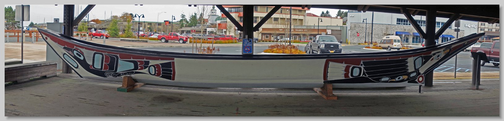
Tlingit Ceremonial Canoe
.")
Mosquito Cove Circuit Hike
The second day I was in Sitka my cousin John drove me 7 miles to the northern end of the road. He dropped me off at Starrigavan Recreation Area while he went to an artesian well to get a supply of water. The recreation area contains the Mosquito Cove Circuit Trail. This boardwalk and gravel trail started out with a forest trail over a low saddle between a point and the main island. The return trail goes along the shore line around the point. Being a rain forest everything was covered with moss and there was the constant sound of water flowing or dripping. This picture was taken as I hiked down from the saddle to Mosquito Cove (in the distance).

Mosquito Cove Circuit Hike

Fortress of the Bear
SSaturday, after the morning wildlife cruse, my cousin drove me the 5.5 miles west of Sitka to the Fortress of the Bear. It is the largest bear rescue facility in the United States and was created in 2003 by a Sitka couple Les and Evy Kinnear. They acquired property from an old pulp mill containing two giant three quarters of an acre wastewater clarifying tanks. These were converted into bear pens with high concrete walls. An observation ramp between the tanks provided a viewing area where I could get within 50 feet of the bears. That ramp was the only concession to tourists. The tanks were otherwise setup for the comfort and stimulation of the bears. This picture is the best one which did not also show the pens.

Fortress of the Bear

Fishing Boat and Rockwell Light House
About a mile across the water from the town is this structure. While it looks like a light house and is built to Coast Guard specifications, in fact it is a tourist rental property. A "local veterinarian and lovable curmudgeon" built it in the 1980s. The rental comes with coastal woods and motorboat transportation to and from the island. I took this picture one morning from below the city approach to the bridge. The fishing boat is heading out for the day.

Fishing Boat and Rockwell Light House

Weekly Wednesday Night Petraborg Family Dinner
Family Tree Time. My mother, Helen, was the youngest of seven children. One of her older brothers, Arthur John Petraborg moved to Alaska as part of the World War II effort. He stayed in Alaska and settled in Sitka and worked as a fisherman. He died in 1990. His son, my first cousin, Arthur J Petraborg Jr. also lived in Sitka, married Jackie and had 3 children - Dorinda, Kathy, and John. He died in 1994. John had two children, Kate and Tyler. Every Wednesday night Jackie Petraborg holds a family dinner and while I was in Sitka, I was invited to it. This picture was taken that night. From left to right: Tyler, Jackie, John and Kate Petraborg; Ed Cragg. Dorinda and Kathy are in a dinner picture in the Week One subalbum.

Weekly Wednesday Night Petraborg Family Dinner


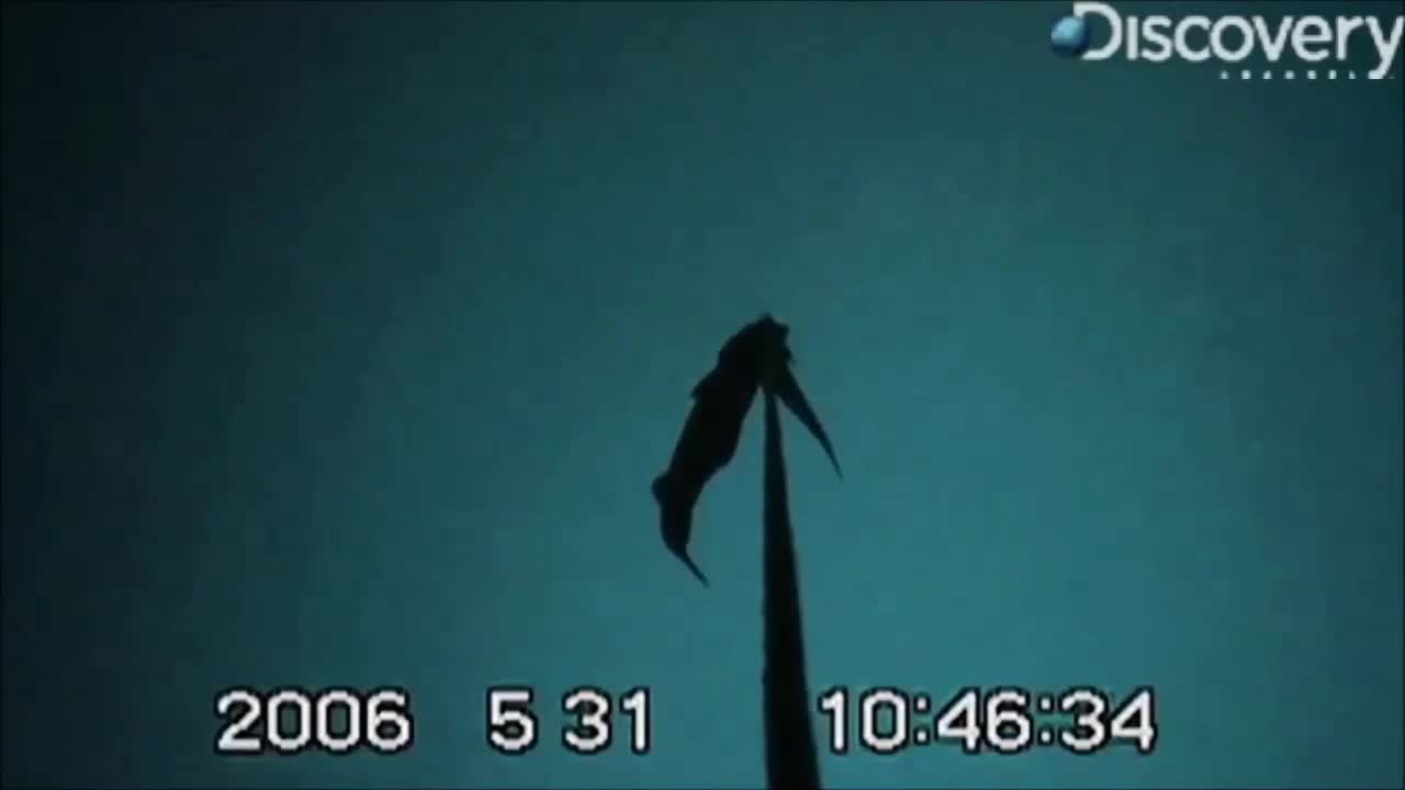
Sperm Whale Stealing Fish
Whalefest included three afternoons of whale related seminars held in Harrigan Centennial Hall. They included talks on rescuing entangled whales, tracking wild swimming whales and using drones in whale research. One interesting facts I learned was that there is evidence that whales can live for hundreds of years. This video is from a talk on sperm whales stealing fish from long line fishermen. A video camera was placed on the fishing line and caught this sperm whale gently putting his mouth around the line and sliding down it until a fish was popped off a hook. The whale then gently disengages from the line and goes after the helpless fish.

Sperm Whale Stealing Fish

Marine Wildlife Cruises
The highlights of Whalefest were two wildlife cruises around Sitka Sound. Departing from the dock below Harrigan Centennial Hall, they ran from 8:45 until 11:30 on both Saturday and Sunday mornings. The cruise was on the Allen Marine Tours catamaran St Nicholas. It was a 78' catamaran which could carry 150 passengers. On Saturday the weather was marginal. There were scattered showers and the boat was in and out of rainy areas. We saw a number of whales, sea otters and other wildlife. Sunday on the other hand was sunny and gorgeous. At times there were so many whales around the boat that there were times I was not sure which way to look, let alone which way to point the camera. the remaining pictures in this album were taken during those cruises.

Marine Wildlife Cruises

Departure From Crescent Bay Harbor
After St Nicholas departed the dock in Crescent Bay Harbor on Sunday morning looked back and took this picture.

Departure From Crescent Bay Harbor

Saturday Wildlife Cruise Rainbow
With all the off and on rain showers, I saw plenty of rainbows while in Sitka. This one, seen during Saturday's cruise, was the best of the lot.

Saturday Wildlife Cruise Rainbow
. After diving they surface for several breaths. When it breathes a whale will exchange up to 90% of its lung capacity. Having a blowhole is normally closed, a whale must flex a muscle to opened it and breathe. After a dive the air in its lungs is very warm and humid. This air is released from the lungs at high pressure (between 200-300 mph). Upon contact with This humid exhale condenses in the relatively cooler air just over the water, resulting in a spout that rises 10-15 feet in the air. These two whales, encountered in southeast Sitka Sound, are probably a mother and calf.")
Spouting Humpback Whales
A whale's spout or is a result of its breathing. A humpback whale ranges from 40 to 50 feet in length and has lungs the size of a small car. On a typical dive a humpback whale will spend up to 15 minutes underwater. Using 90% of the oxygen that enters their lungs whales make the most of each breath (humans use only about 15%). After diving they surface for several breaths. When it breathes a whale will exchange up to 90% of its lung capacity. Having a blowhole is normally closed, a whale must flex a muscle to opened it and breathe. After a dive the air in its lungs is very warm and humid. This air is released from the lungs at high pressure (between 200-300 mph). Upon contact with This humid exhale condenses in the relatively cooler air just over the water, resulting in a spout that rises 10-15 feet in the air. These two whales, encountered in southeast Sitka Sound, are probably a mother and calf.

Spouting Humpback Whales

Residual Whale Spouts
Depending on the temperature and humidity whale spouts can linger for a while. Here is a relatively recent spout among three residual spouts.

Residual Whale Spouts

Whale Back Arch
Upon surfacing after a deep dive, a whale will make several very shallow dives, basically swimming along the surface breathing. When a large whale prepares for a deep dive, it arches its back, moving the central part of his body above water to get a better downward angle. This arching gives the whale a humpbacked appearance. With its head in position, it moves downward. The last thing seen is its fluke. When I saw a hump in the water I knew a fluke would follow. This is the best picture I took of a deep diving hump.

Whale Back Arch

Whale Fluke While Diving
The entire process of a whale making a deep dive and showing its fluke at the end is known as "fluking". The last thing you see before it disappears into the depths is its fluke sticking above the water. I should note that some whales, notably fin whales and minke whales, do not show their fluke on diving. This is my favorite fluke picture from the ones that I took..

Whale Fluke While Diving

Humpback Whale #1377 Fluking
A whale deep diving while heading away from an observers displays the underside of his fluke showing all the markings on it. They are as unique as fingerprints. An Alaska wide fluke identification catalog can be found online at http://www.alaskahumpbacks.org/flukeIDcatalog.html. Posters of flukes of whales known to regularly visit specific high tourist areas are also available. This is whale #1377 starting a deep dive with a final display of its fluke.

Humpback Whale #1377 Fluking

Humpback Whale Collage
Between the two wildlife cruises I took almost 1000 pictures. Not wanting to subject anyone to an excessive number of pictures in one album, if have collected some of the better pictures in this collage.

Humpback Whale Collage
. In the center, behind the harbor rises the officially unnamed, but informally called Peak 5390, so named from its height in feet. It is the highest point on the island and considered a demanding climb.")
Sitka From Across the Sound
About halfway through the cruise we were across the sound, about 3 miles away from the city. This picture looks towards Sitka. The John O'Connell Bridge with down town behind it is on the left. To its right in the center of the picture is Crescent Harbor from which the boat departed (a couple of islands are in front of the harbor). In the center, behind the harbor rises the officially unnamed, but informally called Peak 5390, so named from its height in feet. It is the highest point on the island and considered a demanding climb.

Sitka From Across the Sound

Cormorants On A Rock
Cormorants were constantly flying about Sitka Sound. Here a group of them had landed on a rock in the western part of the sound.

Cormorants On A Rock

A Raft of Sea Otters
Towards the end of each cruise we entered into sea otter habitat. A group of sea otters is known as a raft and they are typically segregated by sex. This is a raft of sea otters from Saturday's cruise..

A Raft of Sea Otters

An Individual Sea Otter
This sea otter picture, taken at maximum 500 mm zoom, was taken towards the end of Sunday's cruise.

An Individual Sea Otter