 know it. The result is a gathering of 3000-4000 eagles to feed on the spawned out salmon. The area has been set aside as a natural preserve with the area around the Klukwan Village being known as the \"Council Grounds\". The Haines Highway, (Alaska Route 7) runs along the river. Two turnouts at 19 miles and 21 miles as well as the Klukwan Village at 22 miles provide excellent eagle viewing points. this is a picture of the sign marking the Mile 21 turnout.")
Alaska Chilkat Bald Eagle Preserve
The Bald Eagle Foundation and Festival owe their existence to a natural phenomenon known as an "alluvial fan reservoir". The braided Chilkat River runs along the track of a former glacier and its bottom is made up of glacial gravel deposits up to 100 feet deep, filled with the river's water. In addition across the river from the Klukwan Native Alaskan Village the Tsirku River empties into the Chilkat with a 4 mile wide delta fan. The bottom of this delta is also deep glacial deposits. Between the summer warming of this deep water and heat from the friction of the fast inflowing tributary waters, a 3-5 mile section of the river remains ice free after the rest of the river has frozen. As a result this river is the site of the last chum salmon run of the season. It seems every eagle in Alaska (and most of those in Western Canada) know it. The result is a gathering of 3000-4000 eagles to feed on the spawned out salmon. The area has been set aside as a natural preserve with the area around the Klukwan Village being known as the "Council Grounds". The Haines Highway, (Alaska Route 7) runs along the river. Two turnouts at 19 miles and 21 miles as well as the Klukwan Village at 22 miles provide excellent eagle viewing points. this is a picture of the sign marking the Mile 21 turnout.


Alaska Chilkat Bald Eagle Preserve
")
Sunrise On The Chilkat
While attending the Eagle Festival I participated in a Photographers Workshop run by Bill McRoberts, the Foundation's official photographer. There were 5 others in the workshop. We would meet at the Foundation building before 8am and drive out to the preserve, getting there about 8:15. At that time of year sunrise occurred a little before 9am, and sunset was about 4:30pm. Being at almost 60° N, in November the sun rises to the southeast and sets in the southwest. Since the Chilkat Valley generally runs southeast - northwest, sunlight enters the valley shortly after sunrise. However the sun would go behind the mountains on the southwest side of the valley around 2:30pm, and we would call it a day for lack of light. This the view looking southeast down the Chilkat at 8:17 as the sun was beginning to rise against a cloudless sky. I will claim credit for the good weather. While being dropped off at BWI airport I reached for my sunglasses, and then told myself "If I take them, I won't need them, if I leave them I would wish I had them." I left them, thus the beautiful sunny weather in Haines :)

Sunrise On The Chilkat

Early Morning View of Klukwan Native Alaskan Village
This is an early morning view of Klukwan Native Alaskan Village as seen from the Milepost 21 turnout. The time was 8:15 in the morning and the Sun would not rise on the valley for another 30+ minutes. The temperature at the time was in the mid 20s and the uneven surface of the river are ice flows coming downstream Near the center of the picture are three white spots around a black center. That is a magpie in flight being followed by a juvenile bald eagle. The dark bumps with white spots on the opposite riverbank are eagles, and while they are almost impossible to see, there are eagles sitting in the trees in the background. During the festival the village residents opened their visitor center for lunch and ran a shuttle every half hour between the turnout and the visitor center. The first day I was out there I took advantage of the shuttle and had moose sausage stew. It was quite good. The visitor center is the building on the extreme left of the picture.

Early Morning View of Klukwan Native Alaskan Village

Photographer Ed
One of the mornings Bill McRoberts took this picture of me taking a picture on the Counsel Grounds. I am using the Sony Alpha 99 camera that I bought the previous year specifically for this trip. The lens is a Sigma 50-500mm F4.5-6.3 which I rented from Borrow Lenses, again specifically for this trip. It was still early in the morning, a little after sunrise. You can see the ice floating on the river. The white tinge on the trees in the distance is hoar frost.

Photographer Ed

Afternoon View of Klukwan Native Alaskan Village
This picture of Klukwan Village was taken in the early afternoon and gives a better view of both the river and the mountains behind the village. Early afternoon is relative - it was 1:45, however the sun would be dropping behind the Chilkat mountains within an hour. The temperature had warmed up to the upper 30s so ice was no longer floating downstream. The highest peak in the background is one of the peaks that define the US/Canada border in this area. As the eagle flies, it is about 15 miles away. However by road along the Haines Highway the border is 19 miles away. The Klukwan visitor center is the building on the right. The dark bumps with white spots on the opposite riverbank are eagles.

Afternoon View of Klukwan Native Alaskan Village

View from Klukwan Native Alaskan Village Visitor Center
This picture was taken right after the lunch in the Klukwan Visitor Center. The mountains in the background are the north end of the Chilkat range. Just south of them is the Tsirku River whose rapidly descending waters feed the alluvial fan reservoir that keeps this area of the Chilkat ice free for the salmon and the eagles. Notice the eagle flying into the tree to join the other three perched there.

View from Klukwan Native Alaskan Village Visitor Center
. It turned out that the temperatures had been warmer than usual, and the Chilkat had not frozen over most of its length. Thus instead 3000-4000 eagles being concentrated in 3-4 miles, they were spread out over 30-40 miles. As a result, instead of thousands of eagles at a given point, there were only hundreds. That was still more than I had ever seen in one place before and well worth the trip.")
View Across Chilkat River From Milepost 21 Turnout
This is a view looking across the river from the Milepost 21 turnout. There are over 30 eagles in those cottonwood trees, and another two perched on the bank below. Many of those who regularly attended the festival were complaining about the lack of eagles. (One man was checking out of Captain's Choice as I checked in for that reason). It turned out that the temperatures had been warmer than usual, and the Chilkat had not frozen over most of its length. Thus instead 3000-4000 eagles being concentrated in 3-4 miles, they were spread out over 30-40 miles. As a result, instead of thousands of eagles at a given point, there were only hundreds. That was still more than I had ever seen in one place before and well worth the trip.

View Across Chilkat River From Milepost 21 Turnout

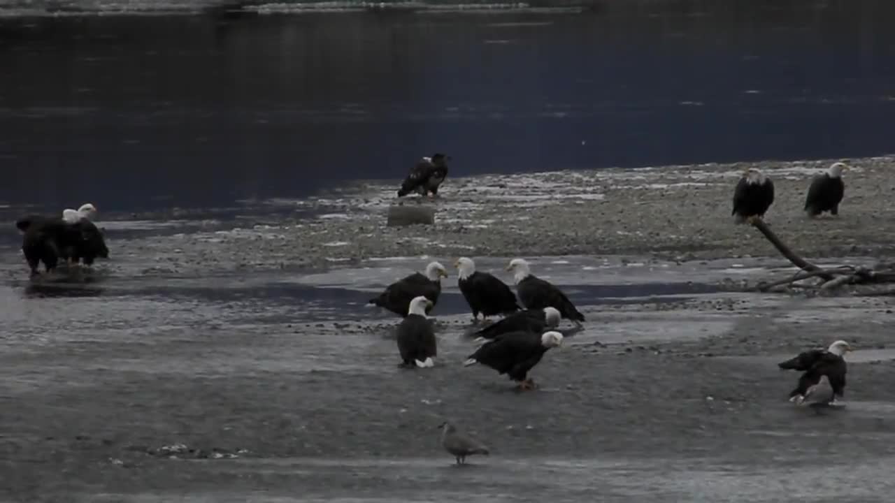
Eagles on the Council Grounds River Flats
ThiThis is a typical view of the Chilkat River flats. Most of the time most of the eagles were simply sitting around awaiting a spawned out salmon to come down stream. Regularly however, as can be seen on the far side next to a channel, two or more eagles would squabble over a chunk of fish. This appeared to occur when one or more eagles decided trying to steal a fish was preferable to continued waiting for one to float by.

Eagles on the Council Grounds River Flats

Eagles In A Cottonwood Tree
Not all the eagles were on the flats or in the trees on the opposite bank. There were quite a few perched in the cottonwoods on our bank. This is a typical tree with half a dozen eagles in it.

Eagles In A Cottonwood Tree


Video of the Council Grounds River Flats
This 2 1/2 minute video shows what it was like along the Chillkat River Flats - do not expect anything exciting - most of the time was spent waiting for something to happen

Video of the Council Grounds River Flats