 research revealed it to be the Seattle Great Wheel. On Wednesday afternoon K.D. and I went to play tourist in downtown Seattle. Our goal was to visit the Great Wheel and the Pike Place Public Market. The wheel opened on June 29, 2012. At 175 feet high, when it opened it was tallest Ferris wheel on the West Coast. A feature of the wheel is that it extends nearly 40 feet over the water beyond the end of the pier. This picture is a view of the wheel taken from the shore end of the pier.")
The Seattle Great Wheel, Pier 57
My flight In to SeaTac airport approached from the north flying over down town Seattle. Out the window I noticed a large white Ferris wheel on the waterfront. Subsequent (Google) research revealed it to be the Seattle Great Wheel. On Wednesday afternoon K.D. and I went to play tourist in downtown Seattle. Our goal was to visit the Great Wheel and the Pike Place Public Market. The wheel opened on June 29, 2012. At 175 feet high, when it opened it was tallest Ferris wheel on the West Coast. A feature of the wheel is that it extends nearly 40 feet over the water beyond the end of the pier. This picture is a view of the wheel taken from the shore end of the pier.


The Seattle Great Wheel, Pier 57

Ed Inside The Seattle Great Wheel
K.D. took this picture of me while we were riding the wheel. We went around three times.

Ed Inside The Seattle Great Wheel

Mount Rainier as seen from the Seattle Great Wheel
From the top of the wheel I had this view of Mount Rainer almost 60 miles to the south-southeast. While it could be said that I was born in its shadow, my first memory of the mountain dates from 1963.With my parents overseas, I was spending my freshman Christmas break with my mother's sisters, Al & Gen. I had taken a redeye flight from LAX to SEA which got in after sunrise. I woke up as the 707 was on approach, probably at ~4000 feet. I raised the window shade and looked up at this magnificent 14,409 foot mountain. In 1990 as part of our Washington to Washington trip Scott and I visited the Sunrise Visitor Center on the northeast slope and Paradise Visitor Center on the south slope. We RV camped that night on the mountain. Finally in 2007 Scott and I orbited the summit at ~13,000 ft in N4261J. I always wanted to climb it, but life intervened and I never had the opportunity. I have finally admitted to myself that I am no longer physically able to summit Rainier.

Mount Rainier as seen from the Seattle Great Wheel

The Space Needle as seen from the Seattle Great Wheel
The Seattle Space Needle was constructed for the 1962 World's Fair. it is 605 ft high and has both an observation deck and a revolving restaurant. I had lunch there with my aunts when I visited them in 1963. Tall buildings blocked the view of the Space Needle from the Great Wheel except when the gondola was at its furthest extent over the water. This picture was taken from that point.

The Space Needle as seen from the Seattle Great Wheel

A Fire Boat Viewed from Pier 57 Below the Seattle Wheel
After getting off of the Seattle Wheel, I noticed this fireboat training out in Elliot Bay.

A Fire Boat Viewed from Pier 57 Below the Seattle Wheel

Ed in Front of the Pike Place Public Market
Across the street and six stories up from the Seattle Great Wheel is the Pike Place Public Market. Having been founded in 1907, it is one of the oldest continuously operated public farmers' markets in the country. One of the notable features of the fish market within is the tradition of fishmongers throwing fish that customers have purchased, before they are wrapped. K.D. took this picture of Ed in front of the market.

Ed in Front of the Pike Place Public Market

A Hallway of the Pike Place Market
A picture down the "Main Arcade" on the top level of the market. It contains a number of cafes and numerous stalls offering fresh fish, vegetables, and other delicacies. This portion of the market was completed in 1907 and restored in 1977. To the opposite direction is the "North Arcade" with stalls offering crafts, flowers, and souvenirs. Ed purchased an eagle belt buckle for his square dancing belts. K.D. also took this picture.

A Hallway of the Pike Place Market

The Seattle Great Wheel As Seen From The Pike Place Market
Being six stories up, the view of Elliot Bay from the Pike Place Market was impressive. This picture looks back towards the Great Seattle Wheel. Throughout the afternoon ferries were coming and going. The one here is the MV Puyallup, one of three Jumbo Mark II Class vessels, the largest in their fleet. It is inbound from Bainbridge Island.

The Seattle Great Wheel As Seen From The Pike Place Market

Bellingham Ferry Terminal
After a rock slide and grounded British Columbia Ferry severely restrict transportation to and from Southeast Alaska the Alaska Marine Highway System extended its routes to include a run to Washington state in 1967. Initially this run terminated in Seattle. Due to lack of priority at Seattle ferry terminals the terminal was moved to Bellingham in 1989. This move also cut many hours from the travel time. A friend drove me from Steven's house to Bellingham. This is a picture of the ferry terminal as seen from the deck of the Malaspina before departure.

Bellingham Ferry Terminal

Sunset at Bellingham
While it was only 5:45, and daylight savings time was still in effect, the sun was already setting. I took this picture from the deck of the Malaspina just before it sailed

Sunset at Bellingham

Sunrise at the Stern of the MV Malaspina
Since sunrise and sunset provides some of the best light for pictures I got up early the first morning on the Malaspina. I made my way to the stern of the Malaspina in time to see the faintest beginnings of twilight This picture was taken about an hour later with the Sun hidden behind the cloud just above the horizon.

Sunrise at the Stern of the MV Malaspina

The Malaspina Solarium at Sunrise
The Alaska Ferry allows passengers to camp on the top deck behind the solarium. In 1995 the boys and I visited Alaska. Our plans had been to take the ferry south from Haines to Bellingham, pitching a tent while we were onboard. Unfortunately a labor dispute threatened to shut down the ferry system, and there was no guarantee that the ship we were planning to take would even run at the time we would have had to leave for Haines. This ferry trip north is my "make-up" almost 20 years later. This picture, taken right after sunrise, is of the Malaspina's solarium with a couple of tents for the hardy souls camping out even though it was a cold November.

The Malaspina Solarium at Sunrise

Orca Pod As Seen From MV Malaspina
Having left the Strait of Georgia separating Vancouver Island from the British Columbia mainland, and passing through Queen Charlotte Sound, a short stretch water open to the Pacific Ocean, the Malaspina entered the 160 mile long Hecate Strait which formed the next leg of the inside passage. Shortly after entering the strait, a pod of orcas passed heading the other direction. This picture is of the entire pod: a female with two calves on the left and a male on the right.

Orca Pod As Seen From MV Malaspina

Male Orca Seen from MV Malaspina
This picture was taken about 45 seconds later. It is of the male orca in the pod. The size of his dorsal fin identifies him as a male.

Male Orca Seen from MV Malaspina

Rainbow In Hecate Strait
Throughout the day the weather alternated between showers and sunshine. About half way through the Hecate Strait the Malaspina passed through a short stretch of open water and ducked in and out of showers. A full rainbow formed ahead of us as we passed back into protected waters. This is a panoramic picture made from several individual images. Use the slider bar on the bottom to see the brighter right hand side.

Rainbow In Hecate Strait

Inner Passage Small Boat Fueling Station
All along the inner passage were a small settlements. They included fishing camps, navigation facilities, and this small boat fueling stations This picture, taken shortly before sunset, is of a fueling station located along the Hecate Strait on the southern tip of Sarah Island, British Columbia.

Inner Passage Small Boat Fueling Station
. The ferry terminal is the bright lights on either side of the group of red lights on the left side of the picture.")
Malaspina's Approach To Ketchikan
I got up early the second morning to watch the Malaspina's arrival at Ketchikan. This is a panoramic view of the waterfront taken from the ship in the 1/2 mile wide Tongass Narrows. Ketchikan has a total area of 5.9 square miles and with just over 8000 year round residents, it is the fifth largest city in Alaska (2010 census). The ferry terminal is the bright lights on either side of the group of red lights on the left side of the picture.

Malaspina's Approach To Ketchikan
, the second busiest in southeast Alaska. Each year almost 200,000 passengers fly through this airport. Lacking any bridge, all these passengers must use this ferry to get back and forth. The airport's runway and a taxiway to can be seen above the ferry. While the bridge was never built, a $26M road to connect the bridge to the airport to the nonexistent bridge's approach was built.")
Bridge to Nowhere Ferry
Those of us who lived through the 2008 presidential campaign will remember "the bridge to nowhere". In reality the bridge was planned to connect Ketchikan with its international airport (KTN), the second busiest in southeast Alaska. Each year almost 200,000 passengers fly through this airport. Lacking any bridge, all these passengers must use this ferry to get back and forth. The airport's runway and a taxiway to can be seen above the ferry. While the bridge was never built, a $26M road to connect the bridge to the airport to the nonexistent bridge's approach was built.

Bridge to Nowhere Ferry
 to Wrangell. This picture was taken one mile off shore on its approach. During all the dock approaches and passages through narrows a crew member is stationed in the bow behind a plexiglas shield to help guide the ship. Wrangell is considered totally rural and the borough has 2300-2400 year round residents. It is the 20th largest \"city\" in Alaska (2010 census). The ferry terminal is the blue ramp to the left of the blue roofed building that can be seen upon magnification of the picture on the extreme left side of the image.")
Malaspina's Approach To Wrangell
After leaving Ketchikan the Malaspina took 6 hours to travel the101 water miles (83 air miles) to Wrangell. This picture was taken one mile off shore on its approach. During all the dock approaches and passages through narrows a crew member is stationed in the bow behind a plexiglas shield to help guide the ship. Wrangell is considered totally rural and the borough has 2300-2400 year round residents. It is the 20th largest "city" in Alaska (2010 census). The ferry terminal is the blue ramp to the left of the blue roofed building that can be seen upon magnification of the picture on the extreme left side of the image.

Malaspina's Approach To Wrangell
. This lady was traveling home to Saxman Village next to Ketchikan. Her business card identified her as a \"Native Regalia Teacher & Facilitator\". She set up in the cafeteria and beaded moccasins toes . Watching her work was fascinating. She could carry on a conversation while working and at times she bead without looking at the work. One of the completed toes is on the right. It is a native frog design. The moccasins were to be Christmas presents for her three granddaughters in North Carolina.")
Moccasin Toe Beading
While the Malaspina traversed the same waters and visited the same cities as Alaskan cruise ships, the clientele could not be more different. While the cruise ships catered to pleasure travelers, most of the Malaspina's passengers were traveling to specific destinations. The full service dining room was replaced by a self service, hot food cafeteria (with reasonably good food). This lady was traveling home to Saxman Village next to Ketchikan. Her business card identified her as a "Native Regalia Teacher & Facilitator". She set up in the cafeteria and beaded moccasins toes . Watching her work was fascinating. She could carry on a conversation while working and at times she bead without looking at the work. One of the completed toes is on the right. It is a native frog design. The moccasins were to be Christmas presents for her three granddaughters in North Carolina.

Moccasin Toe Beading

Family Moving From Washington to Alaska for a Year
This family on the ferry was moving from the Olympic Peninsula in Washington to Cordova Alaska. The husband was a skilled construction worker and he had a contracted to be on the crew building a civic center. They had lived on the Olympic peninsula all their lives and decided to have an adventure

Family Moving From Washington to Alaska for a Year

Family With Nine Children
This large family on the ramp to the ferry had nine children. While en route they celebrated the first birthday of their youngest in the Malaspina's cafeteria.

Family With Nine Children

German Students on Backpacking Trip
I first met these young ladies in the restaurant at the Bellingham ferry terminal. They had full backpacks and were taking a semester off to travel. They pitched and slept in one of the tents outside the solarium. Being on a budget, they brought their own food on board and went grocery shopping while we were in Ketchikan. They got off at Juneau.

German Students on Backpacking Trip
. Once we arrived in Alaska port calls were often enough that the dogs could be walked at the dock. This is a picture of the canine parade while we were docked at Wrangle.")
Parade of Dogs
One of the things that surprised me was the number of dogs on the ship. They had to stay in crates on the car deck during the trip. Normally the car deck was closed to passengers while underway. During the long voyage from Bellingham to Ketchikan the deck was opened to the dog owners for 15 minutes every six hours so they could walk them (and clean up afterwards). Once we arrived in Alaska port calls were often enough that the dogs could be walked at the dock. This is a picture of the canine parade while we were docked at Wrangle.

Parade of Dogs

Truck Loading On The Malaspina
Another thing that surprised me was that the Malaspina loaded passengers and vehicles through the side. Also the size of the embarked vehicles was impressive. In addition to an 18-wheel trailer large construction equipment was carried. This truck and trailer is loading backwards onto the car deck.

Truck Loading On The Malaspina

Ed At The Front Of The Malaspina
This is picture of me on the deck balcony in front of the Malaspina's forward lounge. I spent a lot of time in that lounge. It was taken by a fellow passenger.

Ed At The Front Of The Malaspina

Alaska Ferry Juneau Terminal in Auke Bay
The Malaspina arrived in Juneau at 3:15 am Monday morning. Needless to say with the early arrival, I did not take any pictures at that time. This picture of the ferry terminal in was taken on the flight back into Juneau from Haines. The terminal is located 12 miles northwest of down town at a place ferries can conveniently arrive and depart. I have a cousin who lives in Juneau and I used their house as a "base camp", spending each Monday there while traveling between destinations. They also provided an address to which I could receive and return the rental Sigma 50-500mm zoom lens, saving me a week's rental while I traveled out and back. In addition to housekeeping and laundry, while in Juneau I visited the Mendenhall Glacier, drove to the north end of the 39 mile Glacier Highway, and attended a performance of "Chicago" at Perseverance Theatre. When I made my reconnaissance visit to Perseverance I also drove down to the cruise ship docking area. It was almost deserted, resembling a theme park in off season.

Alaska Ferry Juneau Terminal in Auke Bay
Mendenhall Glacier
That first Monday I was in Juneau I received the rental Sigma 50-500mm zoom lens I planned to use on the rest of trip. I took it out to the Mendenhall Glacier to familiarize myself with its features. Upon arrival in the visitors center parking lot I took this panoramic view of the glacier terminus. The glacier is about 12 miles long, extending from the Juneau Icefield to this point. It has receded 1.75 miles since 1958, when Mendenhall Lake was created, and over 2.5 miles since 1500. With global climate change, its retreat is expended to continue for foreseeable future.

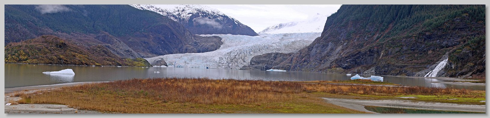
Mendenhall Glacier
 of the Mendenhall Glacier is this waterfall. Officially known as Nugget Falls, it is also referred to as Nugget Creek Falls or Mendenhall Glacier Falls. The falls drop about 375 feet but due to the land contours, only the lower half of the falls can be seen from convenient vantage points. It is a veiling waterfall due to the way the water spreads out at its base - reminiscent of a bridal veil. The source of the falls is a creek originating from the Nugget Glacier. The creek forms a hanging valley before plunges over the falls to Mendenhall Lake.")
Lower Nugget Falls
To the east (right) of the Mendenhall Glacier is this waterfall. Officially known as Nugget Falls, it is also referred to as Nugget Creek Falls or Mendenhall Glacier Falls. The falls drop about 375 feet but due to the land contours, only the lower half of the falls can be seen from convenient vantage points. It is a veiling waterfall due to the way the water spreads out at its base - reminiscent of a bridal veil. The source of the falls is a creek originating from the Nugget Glacier. The creek forms a hanging valley before plunges over the falls to Mendenhall Lake.

Lower Nugget Falls

Iceberg In Mendenhall Lake
While getting to know the rented lens I took many pictures. This is one of the best. It is an iceberg that recently calved off of the face of the glacier. The blue color, characteristic of glacial ice, identifies its recent calving. Once a iceberg has been in the lake for an extended period the blue color fades as seen on the iceberg in the distance.

Iceberg In Mendenhall Lake
. For a more detailed Petraborg family tree, see the Weekly Wednesday Night Petraborg Family Dinner picture in the Week Two sub-album. All three were my guest to see Chicago at Perseverance Theatre.")
Juneau Petraborg Dinner
I have a cousin, Kathy, who lives in Juneau and I used their house as a "base camp", spending each Monday there while traveling between destinations. They also provided an address to which I could receive and return the rental Sigma 50-500mm zoom lens, saving me a week's rental while I traveled out and back. While I was there, another cousin, Dorinda, fixed dinner for us. This picture was taken at that dinner. From left to right: Kathy, Dorinda holding Scruffy, Ed, Dorinda's daughter Lisa holding Allie (sitting on floor). For a more detailed Petraborg family tree, see the Weekly Wednesday Night Petraborg Family Dinner picture in the Week Two sub-album. All three were my guest to see Chicago at Perseverance Theatre.

Juneau Petraborg Dinner

Sergius Narrows, Peril Strait
In planning this trip I was surprised to find that while the Alaska Ferry left Bellingham Washington every Friday at 6pm, its arrival in Juneau, and it's departure/arrival for the Juneau-Sitka leg varied widely. During the trip I learned that the schedule was governed by the tides at Wrangell Narrows and Sergius Narrows. The former is between Wrangle and Petersburg. and the latter between Juneau and Sitka. The Malaspina is one of the largest ships that can navigate these narrows. This is the reason none of the bigger cruise ships travel the real inside passage. The Malaspina transited the Wrangell Narrows after dark. All I could see was flashing red, green and white navigation lights. While it was spectacular, there was insufficient light to take any pictures. We docked in Juneau at 3:15 am. Later, after the ferry went to Haines, Skagway & back, it departed Juneau for Sitka 1:15am reaching the Sergius Narrows about 9:30 am. This picture is of the approach to the narrows. The critical portion, which is dead ahead, is 450 feet long. with a dredged channel 24 feet deep and 300 feet wide. The right side of the channel is the rock wall of Sergius Point. The left side includes a covered rock and a submerged ledge. Because of the fast currents at both high and low tide, the Malaspina must transit the narrows at slack tide.

Sergius Narrows, Peril Strait

The MV Malaspina at the Sitka Ferry Terminal
The Malaspina carries 499 passengers with 53 four-berth and 30 two-berth cabins. Most of the passengers slept on the floor in the various public rooms. It was built in Seattle in 1963, then lengthened and renovated in Portland in 1972. It is 408 feet long, with capacity for 88 vehicles . Its normal cruising speed is 16.5 knots. Onboard amenities included a hot-food cafeteria & dining room, cocktail lounge & bar, solarium, forward & aft lounges and movie theater. The ship is named after the massive Malaspina Glacier situated at the head of the Alaska Panhandle My last voyage on her departed Juneau for Sitka at 1:15 am Tuesday Morning. Most of the voyage to Sitka was in rain. and most of the pictures were marginal at best. The weather began to clear as we approached Sitka. The ferry docked in a hail shower after going through several rain showers. This is my last view of the Malaspina at the Sitka ferry terminal. After disembarking I looked back at the boat and saw this rainbow over the stern.

The MV Malaspina at the Sitka Ferry Terminal