| ▲ Up ▲ | |||||
 Alaska Trip - Seward - MS Zaandam Arrival Holland America's MS Zaandam was scheduled to arrive at 6am, disembark and embark passengers and depart at 8pm. To get these arrival pictures I set the alarm for zero-dark-thirty Sunday morning, only to find that it wasn't all that dark - I took these pictures with available light and 1/8 second exposure. The pictures cover the 30 minutes between the time I got to the breakwater and set up through the Zaandam's final docking. The times on the pictures are Alaska Daylight Time   Alaska Trip - Seward - MS Zaandam Arrival |
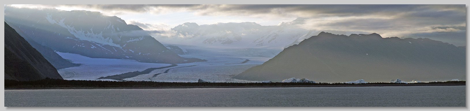
MS Zaandam Departure from Seward The evening before, by the time the wildlife tour boat reached the western side of the bay the weather was overcast and showering. As a result the pictures that I took of Bear Glacier were very poor. Fortunately I had a second chance as the Zaandam cruised by it on the way out of Resurrection Bay. Bear Glacier is the largest glacier in the Kenai Fjords National Park. It originates in the Harding Icefield. It is a rapidly retreating and has a large freshwater lake between its terminus and the old moraine at the entrance to the bay. This panorama was made from four photographs I took at 9:45 pm. The white peaks seen at the front behind the land are not parts of the glacier, they are icebergs which have calved from the glacier and floated across the lake. You can get an idea of the size of these icebergs when you realize that the dark band across the front of the icebergs are full sized trees and just over 10 percent of the iceberg is even above water!. The dark stripes found down the center of a glacier are known as medial moraines formed when the lateral moraines of two large glaciers merge. Bear Glacier is so large that it has two distinct medial moraines. The distance between the two mountains on either side of the glacier is over two miles.  MS Zaandam Departure from Seward |
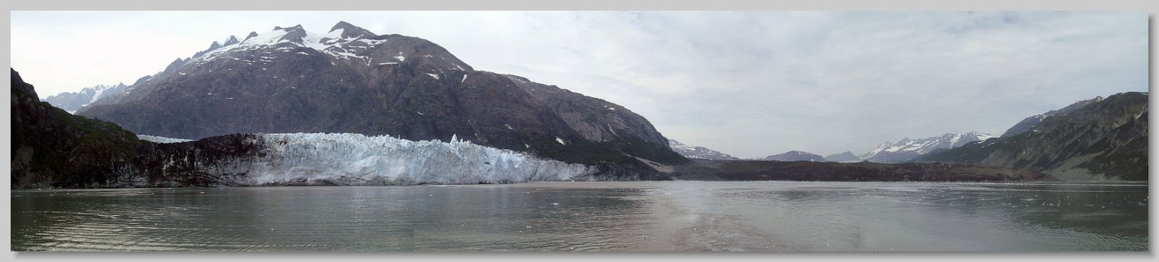
Alaska Trip - Glacier Bay Cruising - Tarr Inlet - Margerie and Grand Pacific Glaciers Panorama This is a panoramic picture made from five photographs taken at the head of Tarr Inlet at the end of Glacier bay. On the right is the Grand Pacific Glacier. Since it is covered by rock debris from landslides and medial moraines it is almost unrecognizable as a glacier. According to one of the National Park Service Rangers on board the Zaandam for this portion of the cruise, the debris is up to 3 feet thick. She referred to it as a "black" glacier. It begins on the southern slopes of Mt Hay in the Saint Elias Mountains and flows for 35 miles first east through British Columbia, then south to Tarr Inlet. At its terminus it is almost 2 miles wide and is the widest glacier in the bay. The ice is about 150 ft thick, extending about 50 feet into the water. All the dirt on the glacier serves to insulate it so calving is relatively rare. On the left of the panorama is Margerie Glacier which is far more recognizable as a glacier. Its source is on the southern slopes of Mount Root. It flows for 21 miles to the northeast also to Tarr Inlet. At its terminus the glacier is a little over 1 mile wide. The face is 250 feet high above the water, and it descends 100 feet into the water. It is this latter depth which allows large cruise ships such as the Zaandam to park close to its face. The ice flows at about 6 feet per day, so calving is common. Due to the ship's location in the inlet, this panorama covers about 90 degrees. Margerie Glacier is closer and perpendicular to the Grand Pacific Glacier. Thus the distortion in their size and relative widths.  Alaska Trip - Glacier Bay Cruising - Tarr Inlet - Margerie and Grand Pacific Glaciers Panorama |
 Alaska Trip - Glacier Bay Cruising - Tarr Inlet - Margerie Glacier Calving Collage This collage show the latter half of a Margerie Glacier calving. While there were three such events during the 2 hour stay at the inlet, I was only able to capture one of them, and that was by luck. As I walked through the door onto the Promenade Deck the calving started. I had my camera in my hand and started taking pictures. The pictures cover about 7 seconds of the ice fall, with the last picture being about 30 seconds later as the waves spread from the fall.  Alaska Trip - Glacier Bay Cruising - Tarr Inlet - Margerie Glacier Calving Collage |
 Alaska Trip - Glacier Bay - Johns Hopkins Inlet - Johns Hopkins Glacier from Jaw Point This is a view of the Johns Hopkins Glacier at the head of the Johns Hopkins taken from Jaw Point. Both the inlet and glacier were named after the university by an alumnus. Harbor Seal pupping occurs from May through August. Since the seals use floating ice at the terminus of the glacier as "haul outs", cruise boats may not get any closer. In this picture the air was quite hazy due to wild fires in western Canada. I had to Photoshop it extensively to eliminate the haze. The visible glacier terminus is over 5 miles away. At the left edge the terminus of Gilman Glacier can also be seen. The two glaciers regularly join and separate as they advance and retreat in their separate courses. Despite the haze, this view from Jaw Point was one of the most magnificent sights of the entire vacation  Alaska Trip - Glacier Bay - Johns Hopkins Inlet - Johns Hopkins Glacier from Jaw Point |
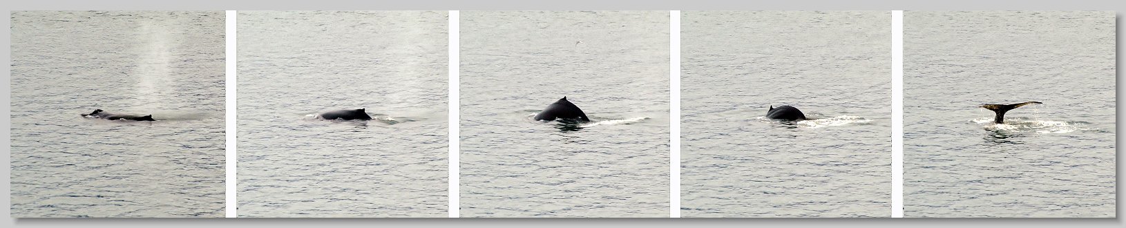
Alaska Trip - Glacier Bay - Outbound Cruise - Humpback Whales Glacier Bay is a Humpback Whale sanctuary. According to the rangers on board, the number of whales spotted in Glacier Bay has been growing every year, This whale was about a mile off the side of the boat. Since we only became aware of its presence when it blew and the speed of sound meant we didn't see it until 5 seconds afterwards, I don't have a picture of the actual blow, however in the first picture of the collage you can still see the blow hole above water and the cloud from its blow. The next 4 pictures cover the approximately one minute that the animal was at the surface up to its final goodbye wave of its fluke. Since it showed its entire 16 ft wide fluke, it is safe to assume that it was departing for a longer, deep dive. These pictures were shot at maximum zoom, so the distance orientation is a bit distorted. However you can see in the fluke picture the whale is swimming away from the ship.  Alaska Trip - Glacier Bay - Outbound Cruise - Humpback Whales |
 the disembarking passengers. I posed for one in Haines. As I came down the ramp I heard the mascot complaining about the heat, and I recognized her voice as one of the cute young assistants, thus the pose :)") Alaska Trip - Haines - Disembarkation Whenever the Zaandam docked the ship's photographer was at the base of the gangplank to take pictures of (and to subsequently sell to) the disembarking passengers. I posed for one in Haines. As I came down the ramp I heard the mascot complaining about the heat, and I recognized her voice as one of the cute young assistants, thus the pose :)  Alaska Trip - Haines - Disembarkation |
 Alaska Trip - Haines - Disembarkation This is the view from the dock looking towards Fort Seward. The Chilkat range is in the background. Just over the mountains is the Muir Inlet of Glacier Bay.  Alaska Trip - Haines - Disembarkation |
 resting on a gravel braid bar in the river. Adult eagles do not get their characteristic white head and tail until they are 5 years old.") Alaska Trip - Haines - Klehini /Chillkat River Float Trip Just outside Haines surrounding the braided Chillkat river is the Chilkat Bald Eagle Preserve. It was established by Alaska in 1982. to "protect and perpetuate the world's largest concentration of Bald Eagles and their critical habitat". A natural phenomenon known as an "alluvial fan reservoir" creates. five miles of open water along the rivers during freezing months. A subterranean reservoir of coarse alluvial material through which the river water must percolate creates friction which results in a warmer water surface temperature and an ice free area. This phenomenon permits chum salmon to spawn late into the year, attracting the eagles. This picture is of a juvenile bald eagle (with a dark head) resting on a gravel braid bar in the river. Adult eagles do not get their characteristic white head and tail until they are 5 years old.  Alaska Trip - Haines - Klehini /Chillkat River Float Trip |
 Alaska Trip - Haines - Photography Tour During the afternoon I went on a photographers tour operated by Rainbow Glacier Adventures The first stop was an eagle nest. According to the guide there was a chick in the nest, but it chose not to make an appearance. This photo is the best of several that I took of the "parent on duty" and the tree surrounding the nest.  Alaska Trip - Haines - Photography Tour |
 Alaska Trip - Haines - Photography Tour The second stop on the photographers' tour was a this little waterfall where we experimented photographing moving water.  Alaska Trip - Haines - Photography Tour |
 Alaska Trip - Haines - Photography Tour The photographers tour headed up to Chilkoot Lake. En route we stopped at the head of Lutak Inlet. This is a view back down the inlet. The boat in the distance is an Alaska Ferry and the mountains in the background are part of the Costal Range  Alaska Trip - Haines - Photography Tour |
 Alaska Trip - Haines - Photography Tour At the same stop this eagle was perched in one of the pine trees across the road  Alaska Trip - Haines - Photography Tour |
 Alaska Trip - Haines - Photography Tour The third attraction at the stop were some isolated tall fireweed  Alaska Trip - Haines - Photography Tour |
 Haines Photography Tour Up at Chilkoot Lake we saw this fisherman make his first catch of the evening  Haines Photography Tour |
 Haines Photography Tour On the return to the Zaandam, there was an excellent view of her docked. The Chilkat range is in the background. Just over the mountains is the Muir Inlet of Glacier Bay.  Haines Photography Tour |
 Alaska Trip - Juneau - Juneau Arrival While arriving at Juneau I took this picture from the ship of the two cabs of the Mt Roberts Tramway passing each other. The tram makes a six-minute up Mount Roberts from the cruise ship docks to ~1,800 ft up the 3800 ft mountain.  Alaska Trip - Juneau - Juneau Arrival |
 Alaska Trip - Juneau - Mount Robinson Tram This view of downtown Juneau was taken about 1/4 of the way up the Mt Roberts Tram. The Zaandam is visible in the lower left of the picture. The other ship whose aft portion is visible is the Celebrity Century  Alaska Trip - Juneau - Mount Robinson Tram |
 Alaska Trip - Juneau - Macaulay DIPAC Salmon Hatchery Chum Salmon were running at the DIPAC Macaulay Salmon Hatchery. These salmon had hatched in this facility several years previously, and were now returning to spawn. This view is of the ocean water below the hatchery teaming with fish and the 450-foot long fish ladder they had to go up in order to get into the hatchery. It takes the fish several weeks to climb the ladder.  Alaska Trip - Juneau - Macaulay DIPAC Salmon Hatchery |
 Alaska Trip - Juneau - Macaulay DIPAC Salmon Hatchery Once inside the hatchery the incoming fish had to be throttled down to a processable number. There were several holding tanks used for this purpose. Here fish are trying to get into one of the tanks.  Alaska Trip - Juneau - Macaulay DIPAC Salmon Hatchery |
  Alaska Trip - Juneau - Macaulay Salmon Hatchery Static pictures do not do the scene at the Macaulay Salmon Hatchery justice. This is a 30 second video I took first of the fish outside, then of the fish inside the hatchery trying to get into the processing area. At the start, in the background you can hear the tour guide talking about the difference between "fish farming" which is illegal in Alaska and the hatchery, which she referred to as "fish ranching"  Alaska Trip - Juneau - Macaulay Salmon Hatchery |
 Alaska Trip - Juneau - Glacier Gardens Rainforest Adventures The trademark of Glacier Gardens in Juneau is this Flower Tower, also known as Upside Down Trees. Fallen trees are turned upside-down, planted into the ground trunk first, their root ball is pruned, then covered with netting, greenery, and blooming flowers.  Alaska Trip - Juneau - Glacier Gardens Rainforest Adventures |
 Alaska Trip - Juneau - Glacier Gardens Rainforest Adventures The ceiling of the Glacier Gardens Visitor Center was covered with these huge hanging baskets.  Alaska Trip - Juneau - Glacier Gardens Rainforest Adventures |
 Alaska Trip - Juneau - Glacier Gardens Rainforest Adventures This Begonia was one of several specimen plants that caught my eye.  Alaska Trip - Juneau - Glacier Gardens Rainforest Adventures |
 Alaska Trip - Ketchikan - Wild Life Tour The next three pictures were taken at Bear Creek outside of Ketchikan, the Zaandam's next stop. The creek leads up to a salmon hatchery. The salmon attracted about 10 eagles. Surprisingly there were no bears in the area. These two eagles were having an argument. They came out of the tree line, clashed a couple of times, then departed the area. This picture was taken during that departure.  Alaska Trip - Ketchikan - Wild Life Tour |
 Alaska Trip - Ketchikan - Wild Life Tour This eagle was perched in a tree, and except for moving his head, did not move for the entire time we were there.  Alaska Trip - Ketchikan - Wild Life Tour |
 Alaska Trip - Ketchikan - Wild Life Tour This is the best picture I took of an eagle in flight during the trip  Alaska Trip - Ketchikan - Wild Life Tour |
 Alaska Tour - Ketchikan - Saxman Native Village This is a picture of the Clan House area in the Saxman Native Village. The picture features the totem poles in the area. On the far right is a plain pole with a figure of Abraham Lincoln extending above the hill in the background. This is an example of a commemorative pole, marking the signing of a peace pact between two rival Tlingit Tribes. The figure of Lincoln at the top of the pole represents the U.S. Revenue Cutter “Lincoln” which was instrumental in finalizing the peace by its presence. The figure of Lincoln is used rather than the ship because the figure on the top of the pose must be an animate object. However the only picture that the cutter had of its namesake was a 3/4 view from the knees up. The carvers thought that was his full picture and thus made his legs very short. Towards the center just to the right of the clan house in the background is another plain pole topped with a black figure with a white face. This is an example of a Ridicule Pole, raised to make fun of a person or clan. Here the person being made fun of is William H. Seward, Secretary of State under Abraham Lincoln. In the summer of 1869, Seward stopped at Ft. Tongass where he was entertained by Chief Ebbits of the Tlingit Nation. Seward was treated like royalty and given many gifts. In Tlingit Culture, he was expected to return the honor by giving gifts to the Tlingit people. He did not do so, so the Tlingit people painted nostrils and ears red, signifying stinginess.  Alaska Tour - Ketchikan - Saxman Native Village |
 Ketchikan Creek Street The tour ended at Creek Street. Physically it is a boardwalk perched on pilings along the banks of Ketchikan Creek. Historically it is a former Red Light District where "both men and salmon swam upstream to spawn". Now it consists of a locally owned tourist shops, museums and galleries. The best known of the buildings is Dolly's House, paying tribute to the city's most celebrated hooker, Dolly Arthur. It is the pastel green house across the creek at the far end. At the end of the boardwalk is "The Married Man’s Trail" which provided patrons a quick exit to avoid hefty fines for being caught at one of the brothels during one of the frequent police raids on the brothels.  Ketchikan Creek Street |
") Alaska Trip - Eagle Collage One of the continuing highlights of the trip for me were all the bald eagles - starting in Anchorage and going all the way through Vancouver. This is a collage of my best eagle pictures, from Haines, Juneau, and Ketchikan. The upper and center right pictures are from the Haines float trip, with the center right bird being a juvenile. The lower right and center left pictures were taken on the Haines photographers' tour. The upper and lower left are from the Ketchikan wildlife tour. While I also took the central picture, it is a bit of a fudge - it is of a captive bird that was in the Juneau Raptor Center at the top of Mount Roberts. These pictures have lead me to two conclusions. I want to go back to Haines for their Alaska Bald Eagle Festival held every November, and I need a newer, full frame camera which would allow me to magnify my wildlife pictures. Now I only need to find the required $$$$$ :)  Alaska Trip - Eagle Collage |
 Alasaka Trip - Inside Passage - Orcas The next day while cruising down the Inside Passage towards Vancouver I saw the only Orcas of the trip. They were several miles off the side of the ship. I took these pictures at the maximum 200 mm zoom, and even with that they were just small images in the center of a pictures of open water. The orca on the left is most definitely a male. The one on the right is probably a female.  Alasaka Trip - Inside Passage - Orcas |
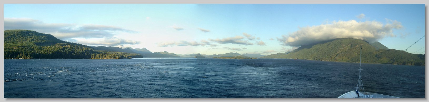
Alaska Trip - Inside Passage The Zaandam entered the strait separating Vancouver Island from the mainland British Columbia in the evening. I took this panorama from the ship's front balcony as we entered the narrowest part of the passage.  Alaska Trip - Inside Passage |
 Alaska Trip - Inside Passage The clouds along this part of the cruise were rather capricious. Here is a hill with a hat that caught my eye.  Alaska Trip - Inside Passage |
 Alaska Trip - Inside Passage In other areas we would see the hilltops through holes in the clouds.  Alaska Trip - Inside Passage |
 Alaska Trip - Inside Passage Sunset from the Inside Passage.  Alaska Trip - Inside Passage |
 Alaska Trip - Vacouver Arrival - Brockton Point Lighthouse On the Zaandam's approach into Vancouver Harbor it cruised by Brockton Point Lighthouse on the north eastern point of Stanley Park.  Alaska Trip - Vacouver Arrival - Brockton Point Lighthouse |
 Alaska Trip - Vacouver Arrival - Vancouver Harbor Panorama The cruise's end was at Canada Place in Vancouver Harbor. The Zaandam docked on the right side of the pier. The Celebrity Century, which the Zaandam had been trailing since Haines is docking on the left side  Alaska Trip - Vacouver Arrival - Vancouver Harbor Panorama |