Crossing the Middle Atlas Mountains
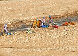
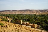
The next day was spent in a 10 hour drive covering ~250 miles from Fez to Erfoud. Unfortunately I took sick the night before so I did not take many pictures. Our first rest stop was at the Jbel Hebri resort in the Middle Atlas Mountains. I wasn't feeling well enough to get off the bus. A little while later we pulled over to see several Barbary apes. The fact that I have no pictures of the event should indicate how bad I felt. Later that afternoon we pulled over at the village of Ouled Chaker along the Ziz River. This is a picture of a few houses in the village with the river's "wadi" in the background. The vegetation seen are date palms. Our guide told us that each tree is tended by a family which owns the dates harvested from them. While a family will tend multiple trees, they need not be contiguous in the wadi.
Image 1 of 19
Crossing the Middle Atlas Mountains
Kasbah Hotel Xaluca
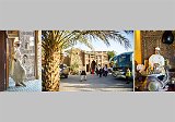
We spent the night at the Kasbah Hotel Xaluca shown in the center image in the collage. This was the most touristy of the hotels we stayed in. The reception was quite nice, being served mint tea( seen in the right hand image) and listening to a Berber musician. There was also an attendant dressed in white "Lawrence of Arabia" flowing robes who greeted all incoming guests. He is shown in the left hand image and can be seen at to the left of the main arch entrance. The hotel had a large central swimming pool and a rustic detached canopy over the bed. Like all of the hotels we stayed in, electrical outlets were scarce. The next morning there were half a dozen camels in a covered pen at the entrance to the hotel. Their purpose was not obvious :)
Image 2 of 19
Kasbah Hotel Xaluca
Macro Fossiles Kasbah
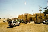
Our first stop the next morning was Macro Fossiles Kasbah, a fossil 'factory'. Obviously they cannot make fossils, but they do convert blocks of limestone with embedded fossils into various products. These embedded fossils include ammonites, squid-like orthoceras, and trilobites. They saw and polish slabs from blocks to make everything from large table tops to small souvenirs. Other blocks are carved out to form sink basins. Blocks containing particularly good fossils will be chipped out and polished to form more elaborate pieces. All these fossil deposits date back millions of years when the Tethys Sea covered the Sahara.
Image 3 of 19
Macro Fossiles Kasbah
Rissani Collage
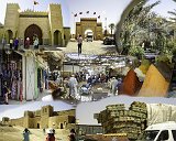
This collage shows our morning in the town of Rissani, the closest town to Erg Chebbi, the sandy desert area where we spending that night. At the center top of the collage is Bab Rissani - the main entrance to Rissani. It is the home of Moulay Ali Cherif, the founder of the current (Alaouite) dynasty ruling Morocco. On the top left is an exterior view of his mausoleum showing its ornate door with one of the smaller contained doors open showing the interior garden. The top right shows another view of the garden. The center pictures are views of the Rissani souk (market). It is open Sundays Tuesdays, and Thursdays. The center picture shows a street in the market. On the left is their equivalent of JoAnn's Fabrics and on the right are multiple piles of spices each over a foot tall. The bottom left shows the Ksar El Fida - a former fortress now no longer used. At the bottom right is a typical, overloaded, cargo truck. the visible bales of hay are simply lashed to the tailgate.
Image 4 of 19
Rissani Collage
Berber Family
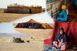
We returned from Rissani to our hotel, boarded several 4x4s and started our trip to the desert. On our way there we stopped and visited a Berber family. This is a collage of their residence. Only two women, a mother and daughter, along with an infant grandchild where there. The men were all away at work. The central image is the tent where they lived. The upper left picture shows a rectangular structure in which the daughter was weaving rugs as shown in the upper right. Below her is her mother who was sitting in the tent awaiting us. With our guide translating she talked about how they lived and answered our questions. The lower left picture is of their well house and several of the goats they maintained. In response to a question about where the men were, she told us that they used trail bikes to go to work.
Image 5 of 19
Berber Family
Erg Chebbi Map
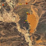
Wikipedia defines and "erg" as a "broad, flat area of desert covered with wind-swept sand and little or no vegetative cover". Morocco has two ergs, a northern one named Erg Chebbi and a southern one named Erg Chigaga (The latter is about 150 miles to the south west of the former). Erg Chebbi sand dunes reach a height of up to almost 500 ft and it spans an area of over 17 miles north to south and 3-5 miles east to west. This is a screen shot of a satellite view of Erg Chebbi. The erg is the bright tan sandy blob to the right of center of the image. The box with the number 10 in it marks the area of our trip. The single red pointer near the top edge of the image shows the location of the Berber family's residence. The other red pointer near the upper left marks the location of Rissani. The distance between the erg and the Berber residence is 6 miles and between the erg and Rossani is about 20 miles
Image 6 of 19
Erg Chebbi Map
Start of Camel Ride into Erg Chebbi
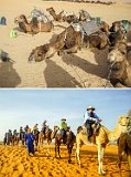
After we left the Berber family we drove to the northwest corner of Efg Chebbi were we met a number of dromedary (one hump) camels and their handlers. They were at the northwest corner of the erg. When we arrived the camels were all resting down on the ground (see the upper picture). We climbed (quite literally) up the back of the camel and sat on the saddle at the top of his hump. As the camel got up I first thought I was going to be pitched forward over his head and then tossed back over his rump. Once everybody was mounted, our small caravan was lead into the erg. The lower picture shows us shortly after we entered the erg proper (note the different sand color). The picture was taken by one of our Berber guides and shows our entire group with the exception of our tour leader Mohammed who is mounted on the camel just off of the picture to the right. The gentleman in blue with an orange head scarf standing on the ground was another of the Berber guides, All of them were dressed in this fashion. Note: the size difference in the camels is due to their sex - the larger are males and the smaller are females.
Image 7 of 19
Start of Camel Ride into Erg Chebbi
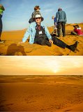
Sunset in the Sahara
We rode the camels abouWe rode the camels about 1/2 miles into the erg. At that point we dismounted on the east side of a dune ridge and told to scramble up to the top. We reached there about 6:30 and sunset was to occur about 7:30. The top picture shows me seated at the crest of the dune. The sky above me shows high scattered clouds and haze. During the hour that we waited until sunset the high clouds and haze increased, particularly to the west. As the lower picture shows, rather than a spectacular sunset which the Sahara is known for, this sunset was rather mediocre :( t 1/2 miles into the erg. At that point we dismounted on the east side of a dune ridge and told to scramble up to the top. We reached there about 6:30 and sunset was to occur about 7:30. The top picture shows me seated at the crest of the dune. The sky above me shows high scattered clouds and haze. During the hour that we waited until sunset the high clouds and haze increased, particularly to the west. As the lower picture shows, rather than a spectacular sunset which the Sahara is known for, this sunset was rather mediocre :(
Image 8 of 19
Sunset in the Sahara
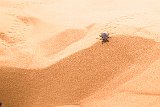
Scarab Beetle
While awaiting sunset I noticed a number of scarab beetles wandering around on the sand. One might think that there would be no life in a middle of a very dry sand pile miles from any open water and extending for miles. However one would be wrong. As this picture shows scarab beetles do well in this environment. There were many beetles and many more tracks. They are a variety of dung beetle which spends much of its time under the sand and comes out near sunrise and sunset when temperatures are cooler. I have been unable to learn where the dung they eat comes from.
Image 9 of 19
Scarab Beetle
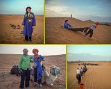
Travel to Sahara Desert Camp Collage
Directly after sunset the guides returned to escort us to our overnight desert camp. Our guide brought a Berber outfit consisting of a decorated blue robe and purple head dress, shown in the upper left picture. As is also seen in that picture the camels which were to be our ride to the camp are at the bottom of the dune. As shown in the upper right our guide had a special way to get one of his charges to the camels. The lower left picture shows Lucinda and our guide at the camels and the lower right picture was taken on our ride to the camp which consists of the black tents in the distance.
Image 10 of 19
Travel to Sahara Desert Camp Collage
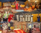
Sahara Desert Camp Collage
We spent that evening in a "Desert Camp". In reality it was a camp set up on the edge of the erg, close enough that they could run electricity to it. As could be seen in the lower left picture of the previous collage and in the center image in this collage, externally the camp was a collection of some rather non-descript dark square tents. However the inside was colorfully decorated with rugs, tapestries, pillows and other fabrics. We were first entertained by a Berber music group that met us when we arrived, and continued their concert in an open square inside the tent complex. We were encouraged to participate in some traditional dances. The gentleman in red with green trim entertained us with gymnastic like movements while balancing a tray of drinks, or individual drinks. We then retired inside one of the tents to have dinner (see the upper right image). The remaining tents were set up as bedrooms with toilet facilities and (slowly) running water (see the center bottom image)
Image 11 of 19
Sahara Desert Camp Collage
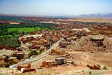
Tinghir
After spending the night in the "desert camp" we first drove back to the hotel, retrieved our luggage, boarded our bus and then drove almost 90 miles to Tinghir, a small city which is the gateway to the Todgha Gorge, The city itself is the center of a large date palm tree oasis which covers about 30 miles along the Wadi Todgha. The oasis ranges from 1500 to 5000 feet wide
Image 12 of 19
Tinghir
Todgha Gorge Collage
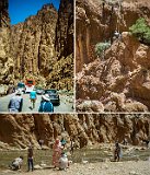
The Todgha Gorge is an impressive narrow and deep canyon created by the Todgha River as it leaves the eastern High Atlas mountains. The most impressive part of the canyon is the last fraction of a mile where it flows out of the mountain. As seen in the upper left picture in this collage, and according to Wikipedia, the floor of the canyon is almost 5000 ft high and in areas as little as 30 ft wide, with sheer and smooth rock walls up to 525 ft high on each side. As seen in the other two pictures, it is also a popular tourist attraction, very popular with rock climbers and day trippers. We were there around 1pm and most of the rock climbers were coming down before the heat of the afternoon. This was also the dry season and the Todgha river was only ankle deep and flowed rather slowly. During the wet season the river can expand and cover the canyon floor with a raging torrent. In the upper left picture the red bus is the one we rode in during our tour and the gentleman in the cyan shirt and tan pants walking towards the bus was our tour guide Mohammed.
Image 13 of 19
Todgha Gorge Collage
Movies in Morocco
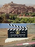
As we learned from our guide, many popular movies were made in Morocco. En route to our evening stop at Ait-Ben-Haddou we drove through the town of Ouarzazate which is noted for the Atlas Film Studios (shown in the lower image). Geographically it is the largest film studio in the world. Even before the establishment of the studio in 1983 the area was used for such films as Lawrence of Arabia. Some scenes of Game of Thrones were shot at Atlas. While not part of the Atlas Studio, the Ksar of Ait-Ben-Haddou has also been uses as a backdrop in many films and Game of Thrones. While the upper part of the Kasar (shown in the upper image) are the original buildings, close examination of the picture shows a city gate and wall which is not part of the Kasar but was constructed for filming of Jewel of the Nile and has been used subsequently for other films
Image 14 of 19
Movies in Morocco
Ksar of Ait-Ben-Haddou
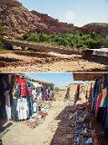
The Ksar of Ait-Ben-Haddou is a fortified village located in the foothills of the Atlas Mountains at a natural gateway to the desert. (Ksar is the term for a Berber fortified village). It is located along the former caravan route between the Sahara and Marrakech. Dating from the 17th century, It is an example of Moroccan earthen clay architecture built entirely of local organic materials with a red mud plaster. While most residents of the village now live in modern residents on the opposite side of the Ounila River, there are still a few families living in the Ksar. The upper picture shows the tourist access - a bridge across the Ounila River. As with all tourist spots, its approach has many souvenir stalls on the path to it. This is shown in the lower picture which was taken while looking backwards towards the bridge which is hidden to the left beyond the stalls.
Image 15 of 19
Ksar of Ait-Ben-Haddou
Ksar Tools
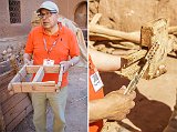
Mohammed (our tour guide) took us into a small courtyard in the Ksar where he showed us some of the tools used to build and in the ksar. In the picture on the left he is showing us a mold used to form clay bricks. The large wooden structure to his left is another mold for large clay bricks. In the picture to the right he is demonstrating a wooden lock . The key, consisting of vertical pegs on a flat board, is inserted in the dark hole in the lock to engage the "pins" and open the lock.
Image 17 of 19
Ksar Tools
Burros Collage
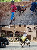
After thinking about it, the use of burros within the Fez medina was understandable. There was no way motorized vehicles could operate on the narrow streets. Goods could only be carried by a human being, pushed in a handcart, or conveyed by a burros. However I did not expect to find burros in use extensively in other areas. These two pictures were taken in Ait-Ben-Haddou. The upper picture shows a burro carrying fabrics and clothing from the ksar souvenir stalls. The lower picture shows a burro carrying a rider and materials along the Ait-Ben-Haddou main street (which is also route 9, the main road between Marrakech and Ouarzazate). I am probably guilty of anthropomorphism, but the burros all seemed to have a resigned expression
Image 18 of 19
Burros Collage
Tizi n'Tichka Pass
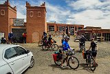
Our drive from Ait-Ben-Haddou to Marrakech was along National Route 9. It took us over the High Atlas mountains using the Tizi n'Tichka pass which is at 7,415 ft. This picture was taken at the rest area and souvenir shops at the top of the pass. It shows what to me was the most surprising aspect of the trip - the number of bicyclists using the road.
Image 19 of 19
Tizi n'Tichka Pass


