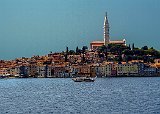
Historic Rovinj
The Royal Clipper's first port of call on our cruise was Rovinj Croatia. After a tender trip to shore we walked through a part of old town including the Rovinj Market and up Ul. Vladimira Švalbe, the pedestrian road that ran directly behind the first row of buildings in this picture. We continued into the wooded park which surrounded Church of St. Euphemia which dominates over the town. Next to the church is a bell-tower designed to resemble the bell-tower of St. Marks in Venice. On the top of the tower is a statue of St Euphemia which also functions as a weather vane.
Image 1 of 34
Historic Rovinj
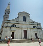
Church of St. Euphemia in Rovinj
This church, dedicated to St Euphemia, dates from 1725. It is the third church to be built on the site. Euphemia was martyred in 304 for refusing to offer sacrifices to the Greek god Ares. Her body was placed in a marble sarcophagus first the town of Chalcedon and until 620 when it transferred to Constantinople. In 800 it disappeared during conflicts with Iconoclasts (icon-slashers). According to the Rovini legend, a marble sarcophagus came floating to the coast a big storm at dawn of July 13, 800. Many Rovinjians tried and failed to haul the it up to what was then the Church of Saint George. Finally, answering to St. Euphemia's call, a small boy with two little cows managed to haul the sarcophagus up the hill. The Rovinjians considered it a miracle, and they proclaimed St. Euphemia their patron-saint . In addition to the sarcophagus, the church contains some magnificent works of art.
Image 2 of 34
Church of St. Euphemia in Rovinj
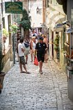
A Street In Old Town Rovinj
After leaving the church we walked down this quaint, steep and narrow cobblestone street. (It was rather treacherous.) Upon reaching the bottom we walked across the isthmus that the city is built on and visited the small boat harbor on the other side. Afterwards we walked back towards the area where the tender docked. Finding a sidewalk gelateria, we stopped for a while before returning to the Royal Clipper.
Image 3 of 34
A Street In Old Town Rovinj

Feline Stalker in Rovinj
I was peacefully walking down Carrera Ul, a main pedestrian street in old-town. Minding my own business,I happen to look up. This kitty looked so much like Halo that I did a double take. It is clear that white kitties with black spots conspire to keep track of their staff. I have been put on notice that where ever I go, my whereabouts will be reported back to kitty central :)
Image 4 of 34
Feline Stalker in Rovinj
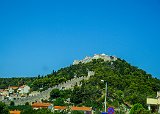
Fortica Španjola in Hvar
After an overnight sail, the Royal Clipper's next port of call was Hvar City on Hvar Island. I took a 4x4 back island tour of the island. We walked through the pedestrian area of old town to the main road where we met the vehicles. While waiting for them to arrive I took this picture of the fortress overlooking the town. It occupies the site of an ancient Illyrian settlement dating from before 500BC. The Byzantines built a citadel there in the 6th century. Construction began on the present fortress in 1282. The Venetians strengthened it in 1557. It saved the lives of Hvar's population, who sheltered here in 1571 when the Turks sacked the town. The Austrians renovated it in the 19th century, adding barracks.
Image 5 of 34
Fortica Španjola in Hvar
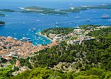
View of Hvar From Fort Napoleon,
The first stop of the tour was Fort Napoleon. Constructed on top of the highest hill (800 ft) overlooking the Town of Hvar the fort was constructed during the Napoleonic wars and the French occupation of the area. Since it is now a Croatian Coast Guard installation the fort itself is not open to the public, but the view is terrific. I took this picture there and it shows Fortica Španjola in the foreground on the right, Hvar city is all the red roofed buildings on the right. The Royal Clipper is anchored in the distance on the right. Its tender docked on the left side of the picture just to the left of the boats in the inner harbor. In the distance are the Pakleni Islands.
Image 6 of 34
View of Hvar From Fort Napoleon,
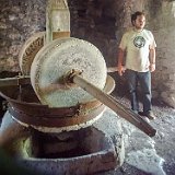
An Olive Press in Malo Grablje, Hvar
Our next stop was the abandoned village of Malo Grablje. Our tour guide made the village come alive. He showed us the rain water collection system and the old olive press (this picture). Most interesting was his description of how caper plants were grown - take a seed, stick it inside a fig and push the combination into a chink in a stone wall. He showed us several plants growing out of walls in the village. The village itself dates to the 15th century and was abandoned in the 1950s when a pest devastated the vineyards and other agriculture of the area. The villagers abandoned their homes and they have been vacant ever since.
Image 7 of 34
An Olive Press in Malo Grablje, Hvar
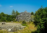
An Upland Herder's Shelter on Hvar Island
During the tour we drove by this upland shelter. Due to the minimal rain there is no extra water available for mortar. Thus in the uplands' basic construction consists of dry walls. Due to the prevailing continuous winds these stones aren’t simply stacked. They must follow a layered construction that effectively blocks the wind. This dry stone technique was used to build small stone houses. Both herders and livestock could shelter in these during adverse weather.
Image 8 of 34
An Upland Herder's Shelter on Hvar Island

Mt Sveti Nikola, Hvar Island
The ultimate destination of our 4x4 tour was Mt. Sveti Nikola(Saint Nicholas, the highest peak on the island of Hvar, (2054 ft, ). These two pictures show the view from the mountain towards Hvar city (on the left) and the summit (on the right). On the summit is a chapel of St. Nicholas dating from the 15th century and the sizable stone cross visible in the picture.
Image 9 of 34
Mt Sveti Nikola, Hvar Island

Old Town Dubrovnik From The Sea
The Royal Clipper's third port of call was the old town of Dubrovnik, Here we saw the advantage of the smaller size of the Royal Clipper. We anchored just off the Old Port of Dubrovnik, took a short tender ride to the shore and entered the city via the port gates. The full sized cruise ships docket on the opposite side of the town's peninsula, over two miles away and their passengers had to be bused to old town.
Image 10 of 34
Old Town Dubrovnik From The Sea
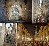
Streets in Old Town Dubrovnik
Stradun is the main street of old town Dubrovnik running between the port and the main (Pile) gate. It is also the lowest part of the town. As a result the aristocrats lived along it. All roads from it required an uphill walk. The upper classes resided just off the Stradum while the plebian classes needed to walk up hill to get to their homes. The further the uphill walk, the lower the class. This collage includes Stadum at night (lower right) and side streets leading up hills. The top two head south towards the ocean. The lower left one heads north up towards Mount Srd. The lady in pink in the upper right image was our tour guide
Image 11 of 34
Streets in Old Town Dubrovnik
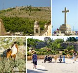
Dubrovnik's Mount Srd Collage
The top left picture in this collage is the 1,352 ft Mount Srd which overlooks Dubrovnik. The picture was taken from within the old town city walls. A cable car runs from just north of the city walls to the summit. The white pole half way is a support tower for the cable car. The building on the left of the summit is Fort Imperial, which was begun by Napoleon, was recently used as a disco, and is currently a museum devoted to the Siege of Dubrovnik in 1991-2. To the fort's right is the upper terminus of the cable car and to its right, in the center of the ridge, is a large cross. (Shown in close up at the top right.) Both the cable car and the cross were destroyed during the siege and have since been rebuilt. The surprise at the top were a herd of cows grazing just outside the door (lower right) and several ponies grazing on the walk to the cross, one of which is seen in the lower left. As a side note, Mount Srđ was originally covered with a forest of oak trees. In old Slavic the forest was called "dubrava", meaning oak grove, from which the name of the city was derived.
Image 12 of 34
Dubrovnik's Mount Srd Collage
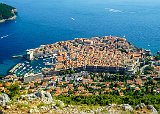
Old Town Dubrovnik From The Upper Cable Car Terminal.
This is the view from the observation platform at the upper cable car viewing platform. The main gate is located on the right side. Running from it, just beyond the city walls, the buildings lining the Stradun are visible, particularly in the expanded image. At the other side of the city is the old harbor. The Royal Clipper tender can be seen departing the upper dock in the harbor. Again, it is clearest in the expanded image.
Image 13 of 34
Old Town Dubrovnik From The Upper Cable Car Terminal.
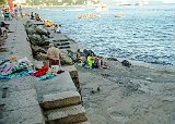
Porporela Beach In Old Town Dubrovnik
Throughout the cruise 'beaches' were pointed out to us. Other than being a place to swim, they had very little in common with American beaches This is a picture of Old Town's Porporela Beach. It is located just outside the city walls located just outside the city walls on a promontory/pier extending into the water. It can be seen on the left side of the preceding picture. The "beach" had no sand, no shallow water, and it was rather small. I watched swimmers jumping directly off of the higher levels directly into the water. Dubrovnik.com describes it as " truly a 'locals' beach" and suggests that tourists should "swim where the locals swim".
Image 14 of 34
Porporela Beach In Old Town Dubrovnik
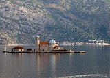
Our Lady Of The Rocks
The fourth stop on the cruise was city and bay of Kotor in Montenegro. The bay is a sunken river valley, similar to a fjord. The Mediterranean Sea's negligible tides allow for very low lying islands such as this one. It is "Our Lady of the Rocks". According to legend on 22 July 1452: two returning sailors discovered a painted icon of the Madonna and Child resting on a rock in a shallow part of the Bay. In exchange for having safely completed a difficult voyage, the sailors subsequently dropped stones around the spot. Others joined them and slowly and islet was created. It soon became a tradition for sailors to drop stones in the water around the islet before a voyage, to ask the Virgin Mother to bring them safely home. A small chapel was built on the islet by 1484. In the 1530s it was expanded to become a full church. After being plundered by pirates in 1624 and being destroyed by an earthquake in 1667, the current church was rebuilt. In modern times, at sunset every July 22 local residents take their boats and throw rocks into the sea around the islet, so it continues to grow. This picture was taken from the Royal Clipper as it sailed up the bay to the town of Kotor.
Image 15 of 34
Our Lady Of The Rocks
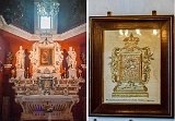
Our Lady Of The Rocks Art
The Royal Clipper sponsored an excursion which included a visit to Our Lady of the Rocks. While the church is small, it is filled with artwork. Two of the works are shown in this collage. The image on the left is of the ornate altar. It was created by the Genoese sculpture Antonio Capellano in 1796. The original painting that washed up on the rock is in the centre of the altar. The image on the right is tapestry sewn over 25 years by a woman awaiting the return of her husband from the sea. While it does have gold and silver threads throughout, she used her own hair for the angles' hair, which starts out brown and gradually turns grey. .
Image 16 of 34
Our Lady Of The Rocks Art
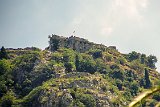
Castle Of San Giovanni (St John)
The old town of Kotor is located at the end of the bay at the base of the Mountain of St John (San Giovanni). Near the top, overlooking the town is a fortress named the Castle Of San Giovanni. It is the highest point of the town's fortifications. Fortified walls zigzag up the mountain from the town to the castle. This picture was taken from the Kotor harbor while awaiting the tender.
Image 17 of 34
Castle Of San Giovanni (St John)
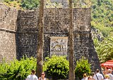
Winged Lion Outside Kotor Sea Gate
The main entrance into Kotor is the Sea Gate. It was constructed in 1555 while the city was under Venetian rule. Thus this winged lion on the city walls just outside the gate.
Image 18 of 34
Winged Lion Outside Kotor Sea Gate
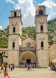
The Cathedral of Saint Tryphon in Kotor
Dating from 1166, this cathedral is dedicated to St Trypon of Campsada, a third century saint from modern day Turkey. Some of his remains are within. The entire frontage was destroyed in a 1667 earthquake (the "Dubrovnik Earthquake"). During the reconstruction the two bell towers were added. However there were not enough funds to finish the tower on the left. It is one of the largest and most ornate buildings in Kotor.
Image 19 of 34
The Cathedral of Saint Tryphon in Kotor
Corfu
The Royal Clipper's last stop in the Adriatic was the city of Corfu on the Island of Corfu, the northern most point of Greece in the Adriatic. With a number of forts, this was the main bulwark protecting Europe from the Ottoman Empire. This panoramic view of the town was taken from the deck of the Royal Clipper while she was docked in the harbor. In the picture, the old fortress (6th century) can be seen on the far left, the new fortress (16th century) is left of center. Corfu old town is between the two forts, The modern city is on the right. In addition to being one of the most fortified places in Europe, Corfu's mild climate made it a popular tourist destination for boh commoners and European royality.
Image 20 of 34
Corfu
Achilleion Palace
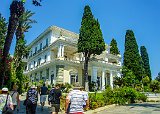
The Achilleion in Corfu was built in 1890 by Austrian Empress Elisabeth (Sisi) to be her summer palace. It was designed with the mythical hero Achilles as its central theme. Extensive statuary and other artworks can be found throughout the house and grounds. In this picture, taken on the approach to the main entrance, several statues can be seen on the balcony corners. Our guide pointed out several delightful items in out of the way locations.
Image 21 of 34
Achilleion Palace
Achilles and Hermes
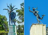
This collage shows two of the statues at the Achilleion. On the left is an imposing statue of Achilles which dominates the end of the formal garden. It was sculpted by Johannes Götz on commission of German Kaiser Wilhelm II. On the right is my favorite - a human scaled statue of the winged god Hermes located on a balcony just off the grand hall on the second floor. I never would have seen it had not our tour guide pointed it out.
Image 22 of 34
Achilles and Hermes
Old Fortress of Corfu
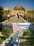
One of the things I learned on this cruise was the influence Venice on the Adriatic. They built a major fortresses at Corfu. The "Old Fort", built on the site of fortresses dating back to the 6th century, is located on a promontory to the east of the city The top picture shows this fortress. Except for the high ground in the center, its bulk is hidden behind the gate and earth embankments. The bridge approaching the gate is over the Contra Fossa, a channel which the Venetians dug separating the promontory from the rest of the island, forming a moat. Today, as seen in the lower picture, that moat serves as a marina for docking small boats.
Image 23 of 34
Old Fortress of Corfu
Giardini Naxos and Mount Etna
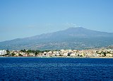
After spending a full day and night sailing across the base of Italy's boot. the Royal Clipper arrived the at the bay at Giardini Naxos on the island of Sicily. This picture was taken on her approach with Mount Etna in the background. During this port call, I had scheduled to take excursion to its summit.
Image 25 of 34
Giardini Naxos and Mount Etna
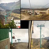
Cable Car Up Mount Etna
The summit excursion began with a 90 minute bus ride to the lower cable car terminus at 6,250' on the south side of Mt Etna. These pictures show various views of the cable car system The left side pictures show the lower and upper (at 9,800') termini. The right side ones show views from inside the car back down to the starting point and up toward the top. The view back shows a number of thriving enterprises designed to separate tourists from their money. I obtained a cup of chocolate "granita", an ice cream predecessor made from sugar, water and flavorings.
Image 26 of 34
Cable Car Up Mount Etna
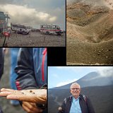
The Summit of Mount Etna
The cable car only goes to 9,800' whereas the summit is 10,991 (give or take the most recent eruption). To travel the final leg to the summit craters we used the 4-wheel drive mini-buses shown in the upper left. We were dropped off below the second highest of the summit craters. From there a guide took us for a trek around the crater. The upper right shows this crater. An active fumarole is visible. The white streak to the left and above it is ice from a recent snow fall! The volcanic ash is such a good insulator that ice can survive nearby eruptions. For scale note the trekkers visible in the upper right corner of the image. The lower left shows our guide's hand holding one of the many summit ladybugs found up there. One of my traveling companions took the picture of me seen at the lower right. One final comment: Tourist access to the summit is so easy that it resembled Times Square rather than an isolated mountain top.
Image 27 of 34
The Summit of Mount Etna
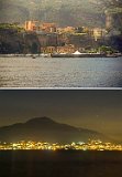
Sorrento
After an overnight trip from Sicily we docked in the Sorrento harbor. These collage shows views from the Royal Clipper. The upper image is a view of the harbor The city proper is 100+ feet up the cliffs. After being tendered to the dock area (on the other side of the breakwater near the pointed tent) we transferred to some small vans which took us up a narrow canyon switchback road to the top of the cliffs. This canyon is to the right behind the multi-story buildings at the base. The top end of the road can be seen just below the horizontal white line of tents at the center top of the cliffs. From there we drove to a lot where we transferred to a bus which took us to Pompeii. The bottom image is a a view of Mount Vesuvius taken after we returned to the Royal Clipper from Pompeii. The ruins are to the right just outside the image
Image 28 of 34
Sorrento

The Pompeii Teatro Grande
This panoramic picture was taken from stage left of a very well preserved Roman Theatre. Known as the Teatro Grande (large theatre), it seats 5000. (The small theater seats 1500). The lower row of seats were reserved for bigwigs such as senators and magistrates. The middle rows were reserved for the middle class with the plebeians being relegated to the back rows, These days "son et lumière" (sound and light) shows are presented in the summer
Image 29 of 34
The Pompeii Teatro Grande
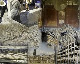
Pompeii Collage
This is a collage of seven images from our tour of Pompeii. Clockwise from the top left: 1) A water fountain featuring a relief head of Concordia Augusta (the goddess marriage and society). 2) An alcove in the House of Menander, with preserved panels containing scenes from the Illiad. 3) The icon marking the entrance to the Lupanare Grande, the largest and most famous brothel in the city. 4) A collection of pottery items found in Pompeii. 5) The Quadriporticus just behind the stage of the Teatro Grande providing an area in which the audience could walk during intermissions. Mount Vesuvius is in the background. 6) A plaster cast of the void left centuries later by decayed bodies under the pumice and ash of the eruption. 7) An angel relief decorating a wall in one of the buildings.
Image 30 of 34
Pompeii Collage

Cruise to Palmarola Collage
The Royal Clipper left Ponza for an 90 minute sail to the island of Palmarola. According to Wikipedia it is a "mostly uninhabited island... primarily a nature reserve". For a nature reserve there were far fewer birds around than I would have expected. The top picture is a telephoto view of Palmarola as we rounded the southern edge of Ponza. The center picture is a view of the northern end of Palmarola as we approached it for docking. Notice the number of pleasure boats of all sizes anchored there. The bottom picture shows an enterprising couple taking advantage of the 'captive audience' and going from boat to boat selling gelato and ice cream treats
Image 33 of 34
Cruise to Palmarola Collage
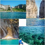
Palmarola Circumnavigation Collage
Jacques Cousteau called Palmarola as "The most b ... /.eautiful Island in the Mediterranean Sea". After anchoring off Palmarola we were offered the opportunity to take a cruise around the island in a tender. This collage made from pictures I took during that cruise. The upper left picture shows one of the semi-inhabited areas of the island. Throughout the trip I was impressed by the clarity of the water . The lower right picture shows this - it looked like the water was too shallow for the tender, but it motored through without a problem.
Image 34 of 34
Palmarola Circumnavigation Collage


