| Comment: |
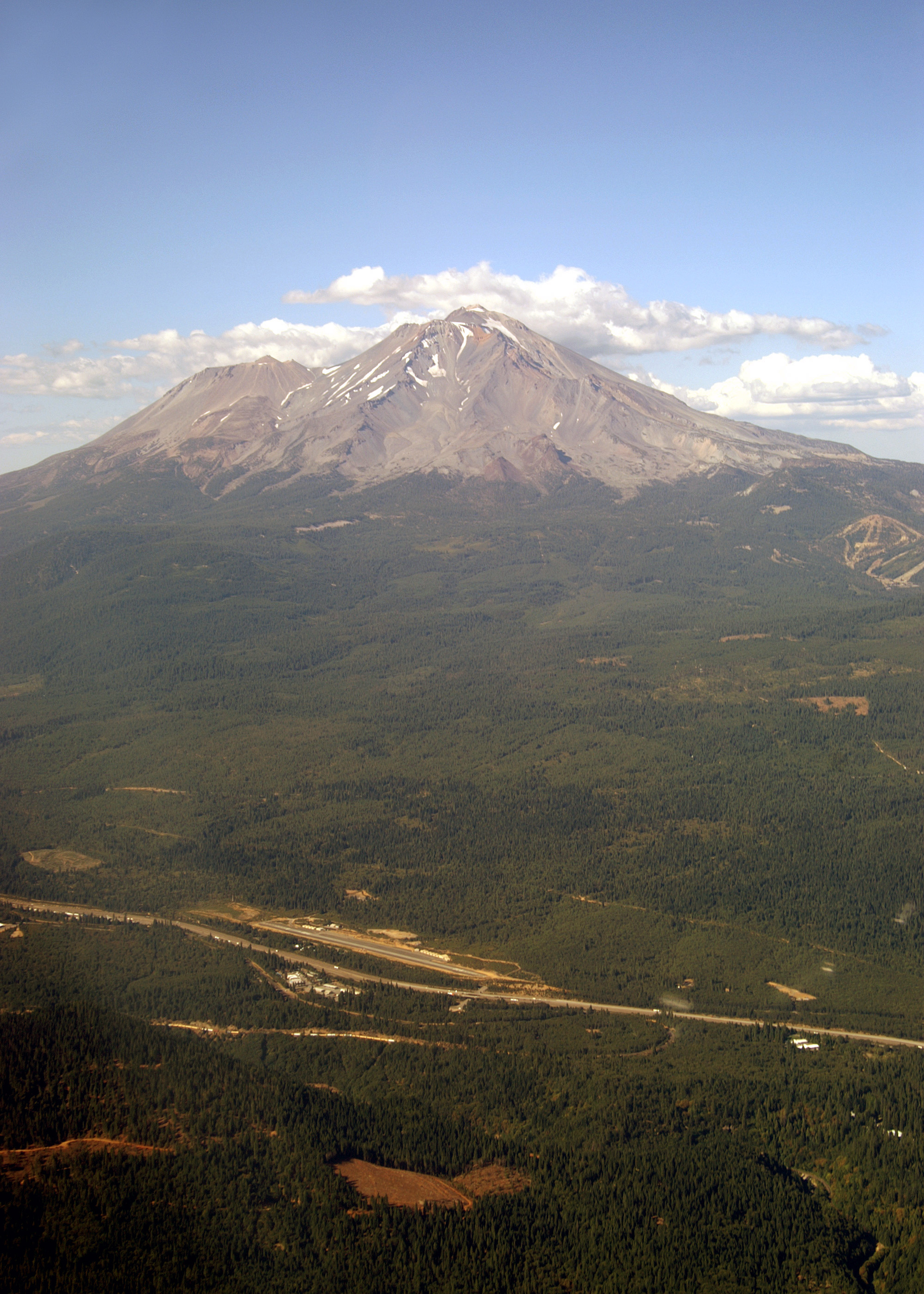
Mount Shasta (14,179') viewed from the south-southwest from a distance of about 15 miles. Julie is flying at 8,500'. Mount Shasta is the second highest (Mount Rainier is higher) and physically the largest volcano (followed by Mount Adams and Mount Rainier) in the Cascades. Its unique feature of two distinct cones is clearly visible. On the right is its symmetrical peak, Hotlum Cone, the youngest and least eroded part of the volcano. On the left, 1 1/2 miles away, is Shastina Cone (12,330'). If it were by itself anywhere else in the Cascades Shastina would be the third highest volcano (after Mount Rainier and Mount Shasta). Remnants of two older cones, Misery Hill and Sergeants Ridge, are also visible. The eroded crater rim of the Misery Hill Cone is the rounded ridge to the left of and about 1000' below the peak. The rust colored area just to the right of the ridge and directly below the peak is the Red Banks pumice layer, a residue from the last eruption from Misery Hill. The upper part of Sergeants Ridge, running to the right from Red Banks is the glacier eroded core of its namesake cone, the oldest. The tree line on Mount Shasta is around 8000'. Prehistoric Indians regarded the area above the tree line as being the realm of the spirits while mankind stayed below. At the base of the volcano, next to Interstate 5, is Dunsmuir Muni-Mott Airport (1O6, elevation 3258'). On 22 July 1990, during a four week cross country trip Scott and Ed drove by this airport. At the time Ed noticed it, and even though he never expected to fly again, he remembered thinking it would be a nice place to land. We would have landed here, but it had no services, so we proceeded to Weed Airport. (O46) |
| Image Date: |
Aug 10, 2007 - 04:51 PM |
| Original: |
PICT1736ac.jpg
, 1.59 MB, 2000 x 2800
|
| Gallery: |
San_Carlos_to_Twin_Oaks_Flight_Album |
| Camera: |
MAXXUM 5D |
| Settings: |
Focal len: 170 mm, Exposure: 1/125s, Aperature: F13.0 |
|